You are here: Home > Network List > CN - Canadian National Seismograph Network Stations List
> Station INK INUVIK, N.W.T. > Earthquake Result Viewer
INK INUVIK, N.W.T. - Earthquake Result Viewer
| Earthquake location: |
Solomon Islands |
| Earthquake latitude/longitude: |
-10.5/160.8 |
| Earthquake time(UTC): |
2003/01/20 (020) 08:43:06 GMT |
| Earthquake Depth: |
33 km |
| Earthquake Magnitude: |
6.7 MB, 7.8 MS, 7.3 MW, 7.2 MW |
| Earthquake Catalog/Contributor: |
WHDF/NEIC |
|
| Network: |
CN Canadian National Seismograph Network |
| Station: |
INK INUVIK, N.W.T. |
| Lat/Lon: |
68.31 N/133.52 W |
| Elevation: |
40 m |
|
| Distance: |
91.0 deg |
| Az: |
19.811 deg |
| Baz: |
243.711 deg |
| Ray Param: |
0.04162904 |
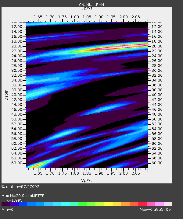
| Estimated Moho Depth: |
20.0 km |
| Estimated Crust Vp/Vs: |
2.00 |
| Assumed Crust Vp: |
6.171 km/s |
| Estimated Crust Vs: |
3.093 km/s |
| Estimated Crust Poisson's Ratio: |
0.33 |
|
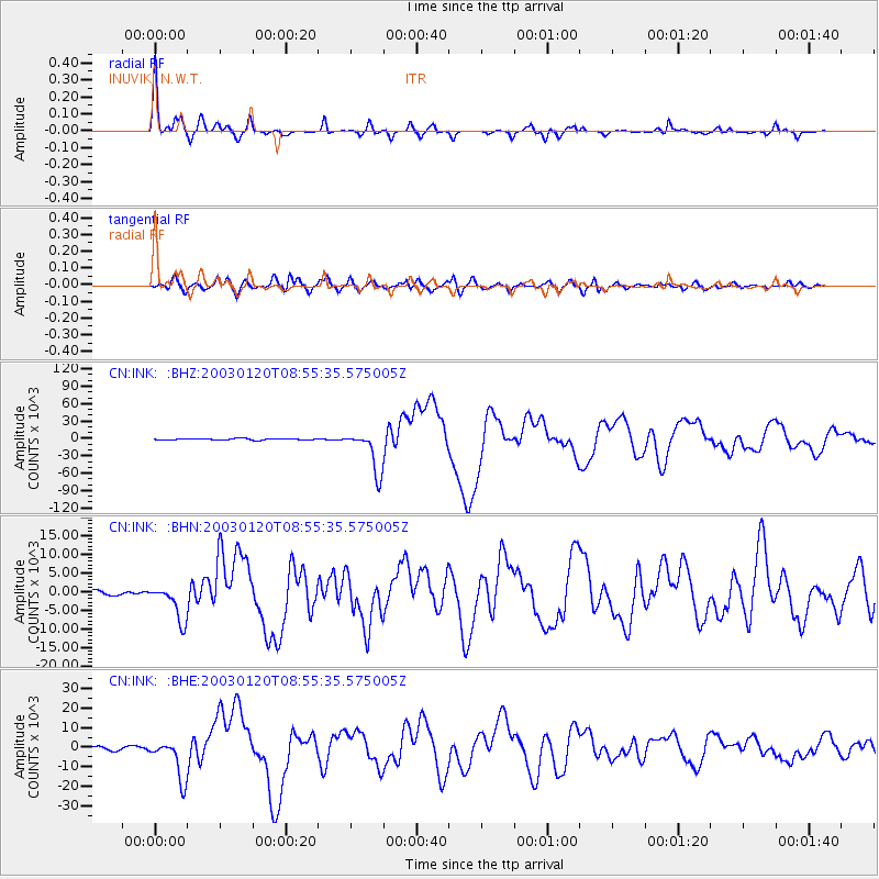
| Radial Match: |
97.27092 % |
| Radial Bump: |
256 |
| Transverse Match: |
91.13187 % |
| Transverse Bump: |
400 |
| SOD ConfigId: |
4714 |
| Insert Time: |
2010-02-27 06:08:59.100 +0000 |
| GWidth: |
2.5 |
| Max Bumps: |
400 |
| Tol: |
0.001 |
|
Signal To Noise
| Channel | StoN | STA | LTA |
| CN:INK: :BHN:20030120T08:55:35.575005Z | 7.804099 | 4809.5317 | 616.2828 |
| CN:INK: :BHE:20030120T08:55:35.575005Z | 7.3148375 | 10289.16 | 1406.615 |
| CN:INK: :BHZ:20030120T08:55:35.575005Z | 28.224571 | 36525.777 | 1294.1127 |
| Arrivals |
| Ps | 3.3 SECOND |
| PpPs | 9.5 SECOND |
| PsPs/PpSs | 13 SECOND |


