You are here: Home > Network List > II - Global Seismograph Network (GSN - IRIS/IDA) Stations List
> Station KAPI Kappang, Sulawesi, Indonesia > Earthquake Result Viewer
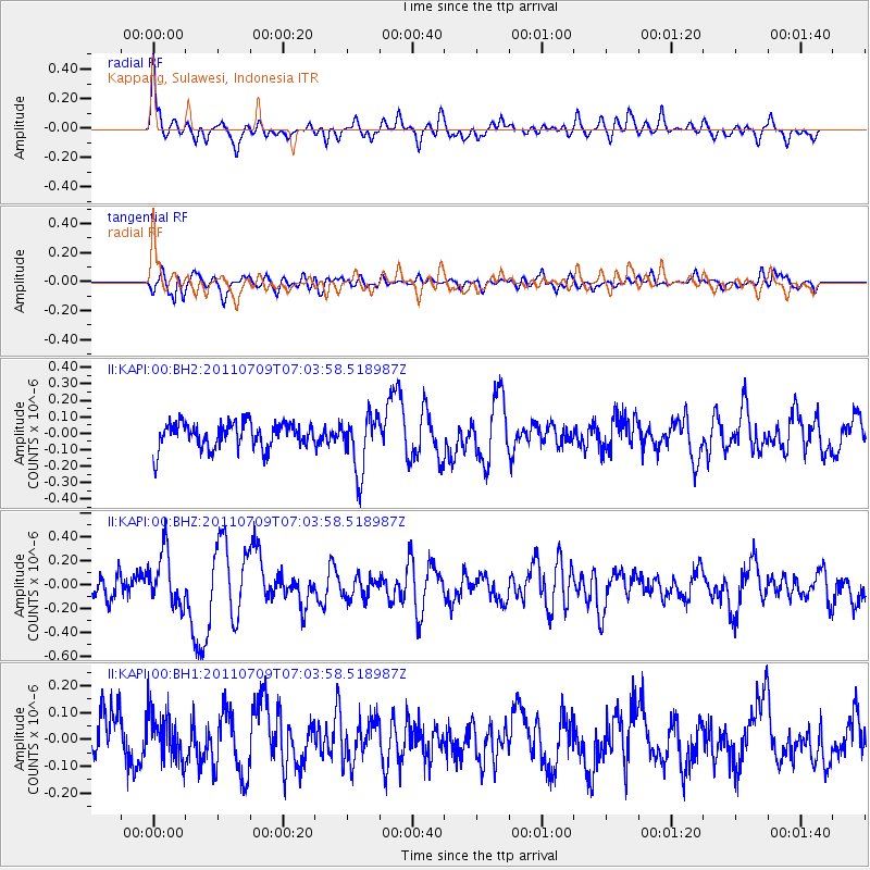
KAPI Kappang, Sulawesi, Indonesia - Earthquake Result Viewer
*The percent match for this event was below the threshold and hence no stack was calculated.
| Earthquake location: |
Tonga Islands |
| Earthquake latitude/longitude: |
-21.2/-174.5 |
| Earthquake time(UTC): |
2011/07/09 (190) 06:53:46 GMT |
| Earthquake Depth: |
16 km |
| Earthquake Magnitude: |
5.9 MW, 5.5 MB, 5.6 MS, 5.8 MW |
| Earthquake Catalog/Contributor: |
NEIC PDE/NEIC PDE-M |
|
| Network: |
II Global Seismograph Network (GSN - IRIS/IDA) |
| Station: |
KAPI Kappang, Sulawesi, Indonesia |
| Lat/Lon: |
5.01 S/119.75 E |
| Elevation: |
300 m |
|
| Distance: |
65.6 deg |
| Az: |
274.18 deg |
| Baz: |
110.909 deg |
| Ray Param: |
$rayparam |
*The percent match for this event was below the threshold and hence was not used in the summary stack. |
|
| Radial Match: |
69.14289 % |
| Radial Bump: |
400 |
| Transverse Match: |
51.40762 % |
| Transverse Bump: |
400 |
| SOD ConfigId: |
558545 |
| Insert Time: |
2013-09-18 21:42:50.416 +0000 |
| GWidth: |
2.5 |
| Max Bumps: |
400 |
| Tol: |
0.001 |
|
Signal To Noise
| Channel | StoN | STA | LTA |
| II:KAPI:00:BHZ:20110709T07:03:58.518987Z | 2.394606 | 2.2275336E-7 | 9.302297E-8 |
| II:KAPI:00:BH1:20110709T07:03:58.518987Z | 0.9252201 | 8.805294E-8 | 9.516973E-8 |
| II:KAPI:00:BH2:20110709T07:03:58.518987Z | 2.2246084 | 1.7338171E-7 | 7.793808E-8 |
| Arrivals |
| Ps | |
| PpPs | |
| PsPs/PpSs | |


