You are here: Home > Network List > US - United States National Seismic Network Stations List
> Station BOZ Bozeman, Montana, USA > Earthquake Result Viewer
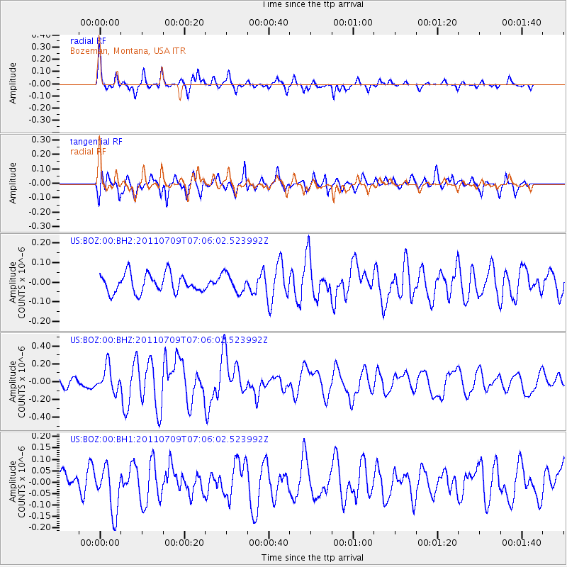
BOZ Bozeman, Montana, USA - Earthquake Result Viewer
*The percent match for this event was below the threshold and hence no stack was calculated.
| Earthquake location: |
Tonga Islands |
| Earthquake latitude/longitude: |
-21.2/-174.5 |
| Earthquake time(UTC): |
2011/07/09 (190) 06:53:46 GMT |
| Earthquake Depth: |
16 km |
| Earthquake Magnitude: |
5.9 MW, 5.5 MB, 5.6 MS, 5.8 MW |
| Earthquake Catalog/Contributor: |
NEIC PDE/NEIC PDE-M |
|
| Network: |
US United States National Seismic Network |
| Station: |
BOZ Bozeman, Montana, USA |
| Lat/Lon: |
45.65 N/111.63 W |
| Elevation: |
1589 m |
|
| Distance: |
87.6 deg |
| Az: |
38.686 deg |
| Baz: |
236.248 deg |
| Ray Param: |
$rayparam |
*The percent match for this event was below the threshold and hence was not used in the summary stack. |
|
| Radial Match: |
68.56272 % |
| Radial Bump: |
271 |
| Transverse Match: |
68.11231 % |
| Transverse Bump: |
400 |
| SOD ConfigId: |
558545 |
| Insert Time: |
2013-09-18 21:43:55.806 +0000 |
| GWidth: |
2.5 |
| Max Bumps: |
400 |
| Tol: |
0.001 |
|
Signal To Noise
| Channel | StoN | STA | LTA |
| US:BOZ:00:BHZ:20110709T07:06:02.523992Z | 2.3347132 | 1.3911635E-7 | 5.9586057E-8 |
| US:BOZ:00:BH1:20110709T07:06:02.523992Z | 1.8579792 | 1.03124655E-7 | 5.5503662E-8 |
| US:BOZ:00:BH2:20110709T07:06:02.523992Z | 0.98595023 | 4.6554472E-8 | 4.721787E-8 |
| Arrivals |
| Ps | |
| PpPs | |
| PsPs/PpSs | |


