You are here: Home > Network List > US - United States National Seismic Network Stations List
> Station HAWA Hanford, Washington, USA > Earthquake Result Viewer
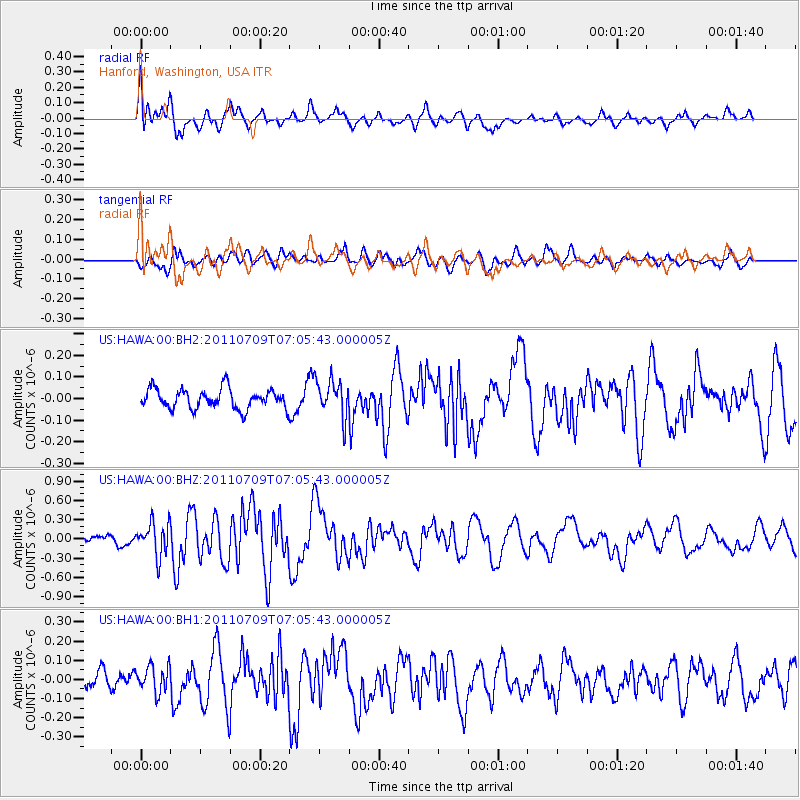
HAWA Hanford, Washington, USA - Earthquake Result Viewer
*The percent match for this event was below the threshold and hence no stack was calculated.
| Earthquake location: |
Tonga Islands |
| Earthquake latitude/longitude: |
-21.2/-174.5 |
| Earthquake time(UTC): |
2011/07/09 (190) 06:53:46 GMT |
| Earthquake Depth: |
16 km |
| Earthquake Magnitude: |
5.9 MW, 5.5 MB, 5.6 MS, 5.8 MW |
| Earthquake Catalog/Contributor: |
NEIC PDE/NEIC PDE-M |
|
| Network: |
US United States National Seismic Network |
| Station: |
HAWA Hanford, Washington, USA |
| Lat/Lon: |
46.39 N/119.53 W |
| Elevation: |
364 m |
|
| Distance: |
83.6 deg |
| Az: |
34.786 deg |
| Baz: |
230.277 deg |
| Ray Param: |
$rayparam |
*The percent match for this event was below the threshold and hence was not used in the summary stack. |
|
| Radial Match: |
76.2488 % |
| Radial Bump: |
400 |
| Transverse Match: |
67.15995 % |
| Transverse Bump: |
400 |
| SOD ConfigId: |
558545 |
| Insert Time: |
2013-09-18 21:44:12.812 +0000 |
| GWidth: |
2.5 |
| Max Bumps: |
400 |
| Tol: |
0.001 |
|
Signal To Noise
| Channel | StoN | STA | LTA |
| US:HAWA:00:BHZ:20110709T07:05:43.000005Z | 3.992127 | 2.5433008E-7 | 6.3707915E-8 |
| US:HAWA:00:BH1:20110709T07:05:43.000005Z | 0.9396647 | 6.845591E-8 | 7.285143E-8 |
| US:HAWA:00:BH2:20110709T07:05:43.000005Z | 1.9035035 | 8.65511E-8 | 4.5469367E-8 |
| Arrivals |
| Ps | |
| PpPs | |
| PsPs/PpSs | |


