You are here: Home > Network List > US - United States National Seismic Network Stations List
> Station WVOR Wild Horse Valley, Oregon, USA > Earthquake Result Viewer
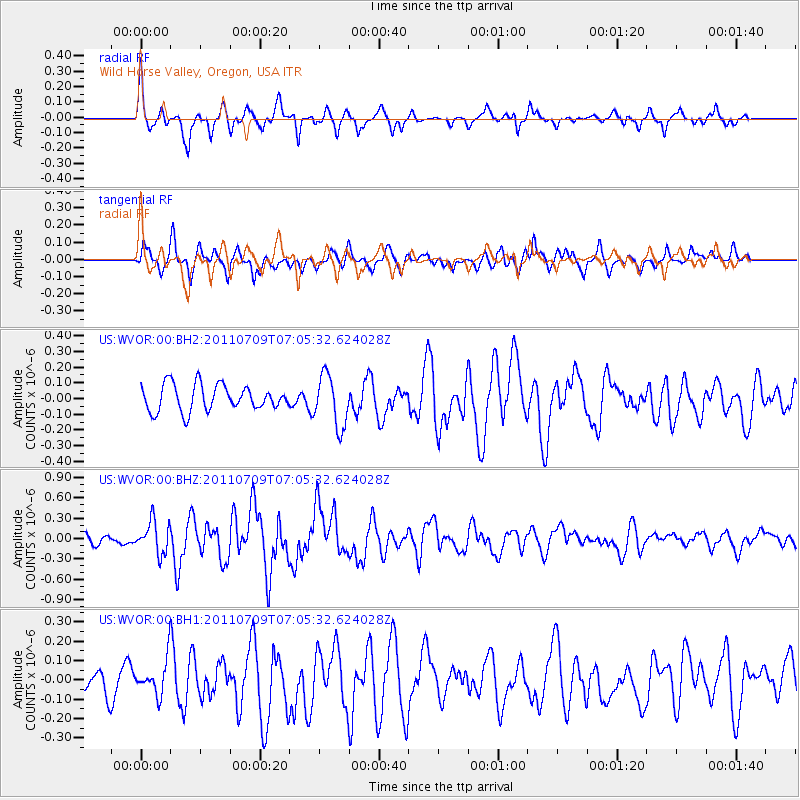
WVOR Wild Horse Valley, Oregon, USA - Earthquake Result Viewer
*The percent match for this event was below the threshold and hence no stack was calculated.
| Earthquake location: |
Tonga Islands |
| Earthquake latitude/longitude: |
-21.2/-174.5 |
| Earthquake time(UTC): |
2011/07/09 (190) 06:53:46 GMT |
| Earthquake Depth: |
16 km |
| Earthquake Magnitude: |
5.9 MW, 5.5 MB, 5.6 MS, 5.8 MW |
| Earthquake Catalog/Contributor: |
NEIC PDE/NEIC PDE-M |
|
| Network: |
US United States National Seismic Network |
| Station: |
WVOR Wild Horse Valley, Oregon, USA |
| Lat/Lon: |
42.43 N/118.64 W |
| Elevation: |
1344 m |
|
| Distance: |
81.6 deg |
| Az: |
38.289 deg |
| Baz: |
231.351 deg |
| Ray Param: |
$rayparam |
*The percent match for this event was below the threshold and hence was not used in the summary stack. |
|
| Radial Match: |
66.761894 % |
| Radial Bump: |
325 |
| Transverse Match: |
61.716854 % |
| Transverse Bump: |
400 |
| SOD ConfigId: |
558545 |
| Insert Time: |
2013-09-18 21:45:01.123 +0000 |
| GWidth: |
2.5 |
| Max Bumps: |
400 |
| Tol: |
0.001 |
|
Signal To Noise
| Channel | StoN | STA | LTA |
| US:WVOR:00:BHZ:20110709T07:05:32.624028Z | 4.2880135 | 2.3672774E-7 | 5.5206854E-8 |
| US:WVOR:00:BH1:20110709T07:05:32.624028Z | 1.4840019 | 9.174931E-8 | 6.18256E-8 |
| US:WVOR:00:BH2:20110709T07:05:32.624028Z | 1.9866003 | 1.6396523E-7 | 8.253559E-8 |
| Arrivals |
| Ps | |
| PpPs | |
| PsPs/PpSs | |


