You are here: Home > Network List > II - Global Seismograph Network (GSN - IRIS/IDA) Stations List
> Station WRAB Tennant Creek, NT, Australia > Earthquake Result Viewer
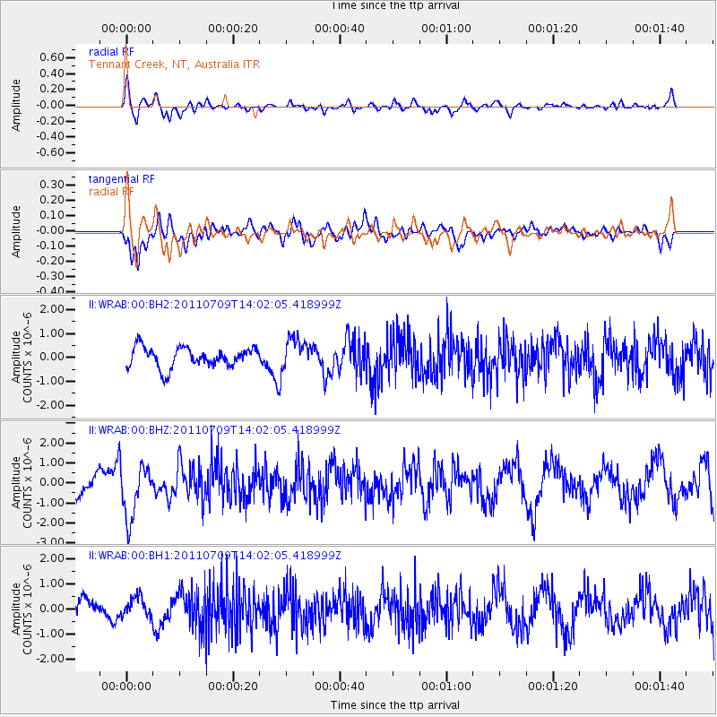
WRAB Tennant Creek, NT, Australia - Earthquake Result Viewer
*The percent match for this event was below the threshold and hence no stack was calculated.
| Earthquake location: |
Kermadec Islands, New Zealand |
| Earthquake latitude/longitude: |
-29.4/-177.1 |
| Earthquake time(UTC): |
2011/07/09 (190) 13:54:23 GMT |
| Earthquake Depth: |
19 km |
| Earthquake Magnitude: |
5.9 MW, 5.6 MB, 5.7 MW, 5.7 MS |
| Earthquake Catalog/Contributor: |
NEIC PDE/NEIC PDE-M |
|
| Network: |
II Global Seismograph Network (GSN - IRIS/IDA) |
| Station: |
WRAB Tennant Creek, NT, Australia |
| Lat/Lon: |
19.93 S/134.36 E |
| Elevation: |
366 m |
|
| Distance: |
44.8 deg |
| Az: |
270.69 deg |
| Baz: |
111.947 deg |
| Ray Param: |
$rayparam |
*The percent match for this event was below the threshold and hence was not used in the summary stack. |
|
| Radial Match: |
58.33191 % |
| Radial Bump: |
400 |
| Transverse Match: |
64.67409 % |
| Transverse Bump: |
400 |
| SOD ConfigId: |
558545 |
| Insert Time: |
2013-09-18 21:47:26.200 +0000 |
| GWidth: |
2.5 |
| Max Bumps: |
400 |
| Tol: |
0.001 |
|
Signal To Noise
| Channel | StoN | STA | LTA |
| II:WRAB:00:BHZ:20110709T14:02:05.418999Z | 2.8862877 | 1.320638E-6 | 4.5755593E-7 |
| II:WRAB:00:BH1:20110709T14:02:05.418999Z | 1.2651707 | 3.9300664E-7 | 3.1063527E-7 |
| II:WRAB:00:BH2:20110709T14:02:05.418999Z | 1.5421376 | 6.3790065E-7 | 4.1364703E-7 |
| Arrivals |
| Ps | |
| PpPs | |
| PsPs/PpSs | |


