You are here: Home > Network List > IU - Global Seismograph Network (GSN - IRIS/USGS) Stations List
> Station PMG Port Moresby, New Guinea > Earthquake Result Viewer
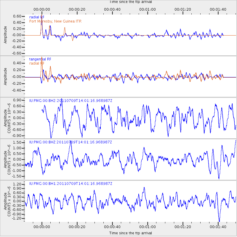
PMG Port Moresby, New Guinea - Earthquake Result Viewer
*The percent match for this event was below the threshold and hence no stack was calculated.
| Earthquake location: |
Kermadec Islands, New Zealand |
| Earthquake latitude/longitude: |
-29.4/-177.1 |
| Earthquake time(UTC): |
2011/07/09 (190) 13:54:23 GMT |
| Earthquake Depth: |
19 km |
| Earthquake Magnitude: |
5.9 MW, 5.6 MB, 5.7 MW, 5.7 MS |
| Earthquake Catalog/Contributor: |
NEIC PDE/NEIC PDE-M |
|
| Network: |
IU Global Seismograph Network (GSN - IRIS/USGS) |
| Station: |
PMG Port Moresby, New Guinea |
| Lat/Lon: |
9.40 S/147.16 E |
| Elevation: |
90 m |
|
| Distance: |
38.9 deg |
| Az: |
293.414 deg |
| Baz: |
125.747 deg |
| Ray Param: |
$rayparam |
*The percent match for this event was below the threshold and hence was not used in the summary stack. |
|
| Radial Match: |
72.10575 % |
| Radial Bump: |
400 |
| Transverse Match: |
40.917183 % |
| Transverse Bump: |
400 |
| SOD ConfigId: |
558545 |
| Insert Time: |
2013-09-18 21:47:59.444 +0000 |
| GWidth: |
2.5 |
| Max Bumps: |
400 |
| Tol: |
0.001 |
|
Signal To Noise
| Channel | StoN | STA | LTA |
| IU:PMG:00:BHZ:20110709T14:01:16.968987Z | 1.9700212 | 6.3125253E-7 | 3.2042934E-7 |
| IU:PMG:00:BH1:20110709T14:01:16.968987Z | 1.2426381 | 3.0762325E-7 | 2.4755659E-7 |
| IU:PMG:00:BH2:20110709T14:01:16.968987Z | 0.90048146 | 4.2698383E-7 | 4.7417282E-7 |
| Arrivals |
| Ps | |
| PpPs | |
| PsPs/PpSs | |


