You are here: Home > Network List > US - United States National Seismic Network Stations List
> Station HAWA Hanford, Washington, USA > Earthquake Result Viewer
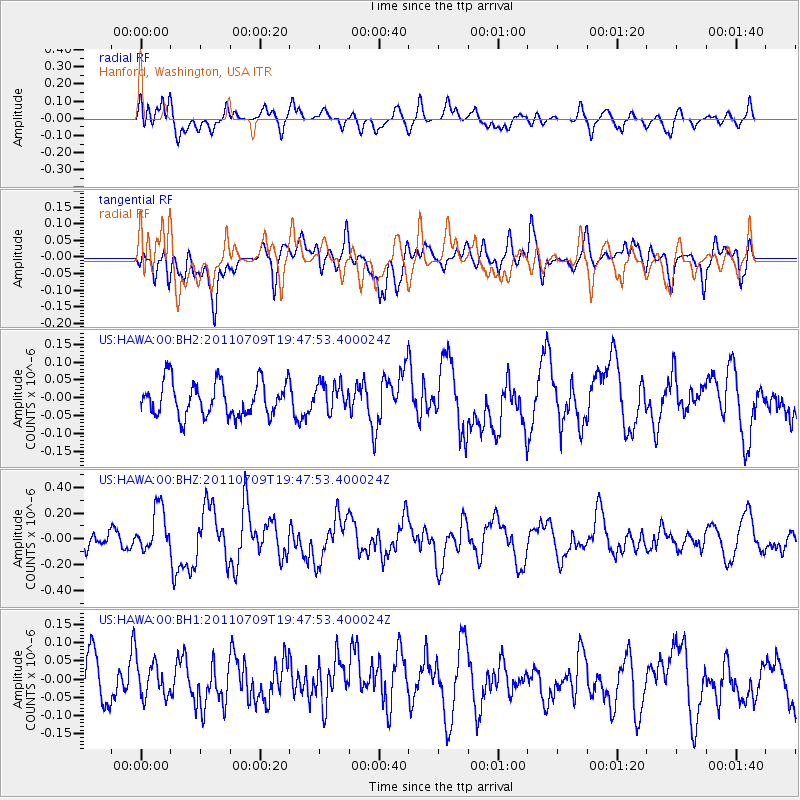
HAWA Hanford, Washington, USA - Earthquake Result Viewer
*The percent match for this event was below the threshold and hence no stack was calculated.
| Earthquake location: |
Kermadec Islands, New Zealand |
| Earthquake latitude/longitude: |
-29.4/-177.0 |
| Earthquake time(UTC): |
2011/07/09 (190) 19:35:18 GMT |
| Earthquake Depth: |
15 km |
| Earthquake Magnitude: |
5.5 MB, 5.8 MS, 5.9 MW, 5.7 MW |
| Earthquake Catalog/Contributor: |
WHDF/NEIC |
|
| Network: |
US United States National Seismic Network |
| Station: |
HAWA Hanford, Washington, USA |
| Lat/Lon: |
46.39 N/119.53 W |
| Elevation: |
364 m |
|
| Distance: |
91.6 deg |
| Az: |
35.719 deg |
| Baz: |
227.374 deg |
| Ray Param: |
$rayparam |
*The percent match for this event was below the threshold and hence was not used in the summary stack. |
|
| Radial Match: |
61.8211 % |
| Radial Bump: |
400 |
| Transverse Match: |
55.778816 % |
| Transverse Bump: |
400 |
| SOD ConfigId: |
558545 |
| Insert Time: |
2013-09-18 21:53:07.689 +0000 |
| GWidth: |
2.5 |
| Max Bumps: |
400 |
| Tol: |
0.001 |
|
Signal To Noise
| Channel | StoN | STA | LTA |
| US:HAWA:00:BHZ:20110709T19:47:53.400024Z | 2.243796 | 1.7184699E-7 | 7.658761E-8 |
| US:HAWA:00:BH1:20110709T19:47:53.400024Z | 0.9756856 | 4.8161272E-8 | 4.9361464E-8 |
| US:HAWA:00:BH2:20110709T19:47:53.400024Z | 0.82936954 | 3.990397E-8 | 4.811362E-8 |
| Arrivals |
| Ps | |
| PpPs | |
| PsPs/PpSs | |


