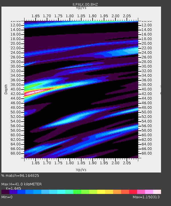
PALK Pallekele, Sri Lanka - Earthquake Result Viewer
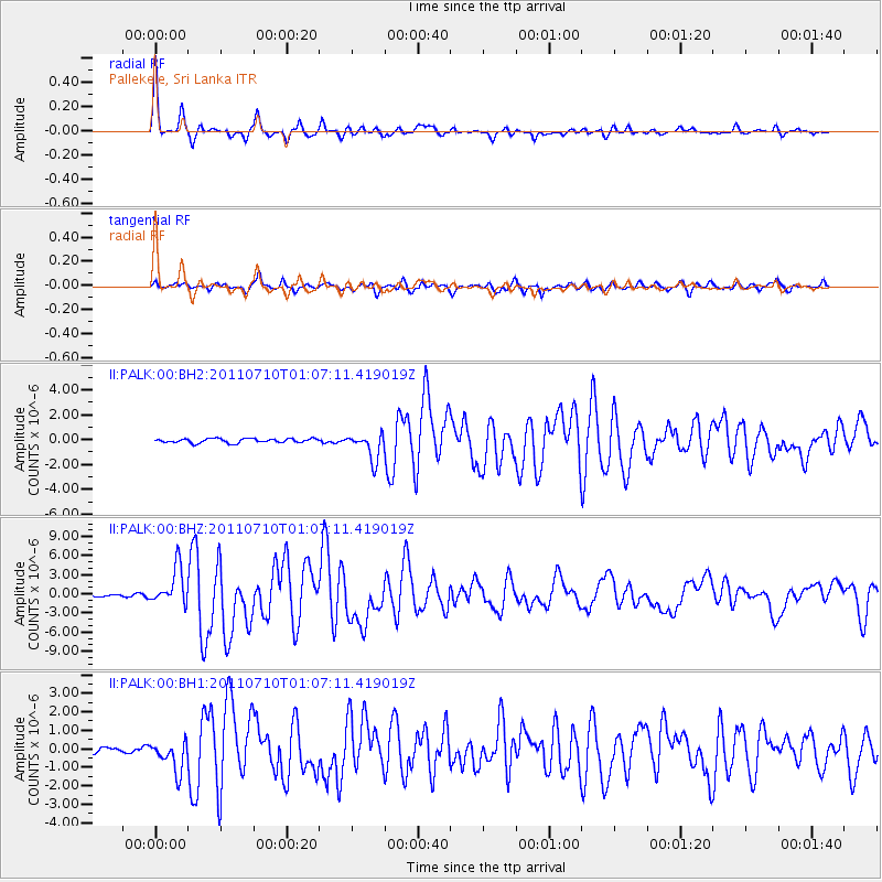
Earthquake location: Off East Coast Of Honshu, Japan
Earthquake latitude/longitude: 38.0/143.3
Earthquake time(UTC): 2011/07/10 (191) 00:57:10 GMT
Earthquake Depth: 23 km
Earthquake Magnitude: 6.6 MB, 7.0 MS, 7.0 MW, 7.0 MW
Earthquake Catalog/Contributor: WHDF/NEIC
Network: II Global Seismograph Network (GSN - IRIS/IDA)
Station: PALK Pallekele, Sri Lanka
Lat/Lon: 7.27 N/80.70 E
Elevation: 460 m
Distance: 64.0 deg
Az: 258.373 deg
Baz: 51.227 deg
Ray Param: 0.05916892
Estimated Moho Depth: 41.0 km
Estimated Crust Vp/Vs: 1.64
Assumed Crust Vp: 6.545 km/s
Estimated Crust Vs: 3.979 km/s
Estimated Crust Poisson's Ratio: 0.21
Radial Match: 96.164825 %
Radial Bump: 263
Transverse Match: 82.54447 %
Transverse Bump: 400
SOD ConfigId: 558545
Insert Time: 2013-09-18 21:54:02.848 +0000
GWidth: 2.5
Max Bumps: 400
Tol: 0.001

Signal To Noise

ChannelStoNSTALTA
II:PALK:00:BHZ:20110710T01:07:11.419019Z12.3561232.92458E-62.3669075E-7
II:PALK:00:BH1:20110710T01:07:11.419019Z3.7609268.2558364E-72.1951605E-7
II:PALK:00:BH2:20110710T01:07:11.419019Z6.3956991.0648143E-61.6648913E-7
Arrivals
Ps4.2 SECOND
PpPs16 SECOND
PsPs/PpSs20 SECOND