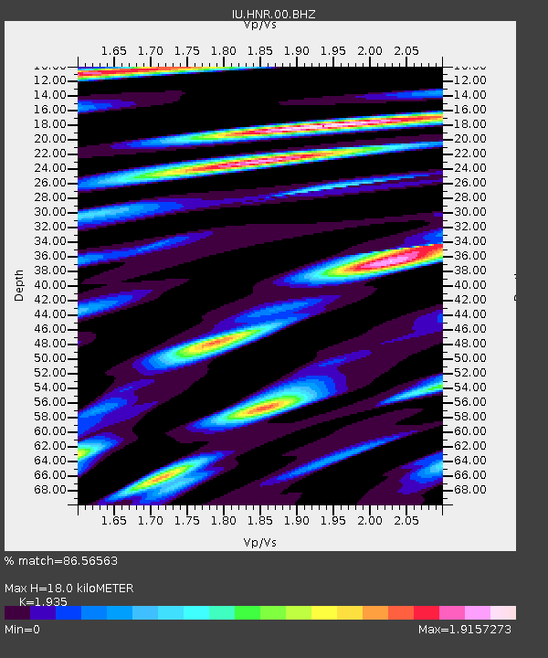
HNR Honiara, Solomon Islands - Earthquake Result Viewer
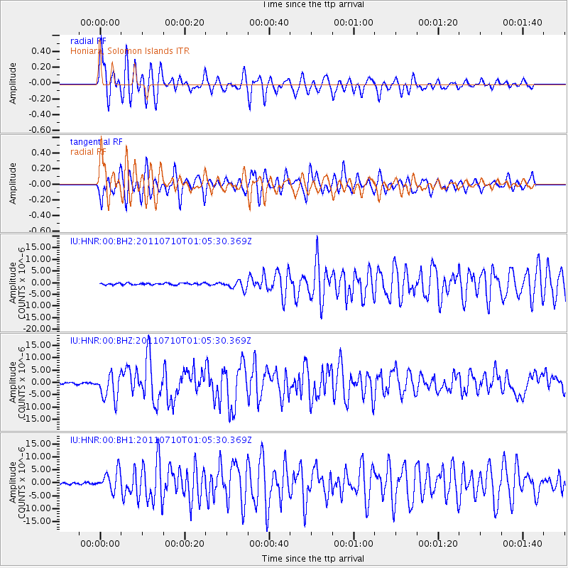
Earthquake location: Off East Coast Of Honshu, Japan
Earthquake latitude/longitude: 38.0/143.3
Earthquake time(UTC): 2011/07/10 (191) 00:57:10 GMT
Earthquake Depth: 23 km
Earthquake Magnitude: 6.6 MB, 7.0 MS, 7.0 MW, 7.0 MW
Earthquake Catalog/Contributor: WHDF/NEIC
Network: IU Global Seismograph Network (GSN - IRIS/USGS)
Station: HNR Honiara, Solomon Islands
Lat/Lon: 9.44 S/159.95 E
Elevation: 100 m
Distance: 49.7 deg
Az: 158.21 deg
Baz: 342.717 deg
Ray Param: 0.06847878
Estimated Moho Depth: 18.0 km
Estimated Crust Vp/Vs: 1.93
Assumed Crust Vp: 6.183 km/s
Estimated Crust Vs: 3.195 km/s
Estimated Crust Poisson's Ratio: 0.32
Radial Match: 86.56563 %
Radial Bump: 400
Transverse Match: 87.068756 %
Transverse Bump: 400
SOD ConfigId: 558545
Insert Time: 2013-09-18 21:54:34.796 +0000
GWidth: 2.5
Max Bumps: 400
Tol: 0.001

Signal To Noise

ChannelStoNSTALTA
IU:HNR:00:BHZ:20110710T01:05:30.369Z15.5827835.305906E-63.40498E-7
IU:HNR:00:BH1:20110710T01:05:30.369Z11.3196593.927793E-63.4698863E-7
IU:HNR:00:BH2:20110710T01:05:30.369Z5.4922841.914162E-63.485184E-7
Arrivals
Ps2.9 SECOND
PpPs8.1 SECOND
PsPs/PpSs11 SECOND