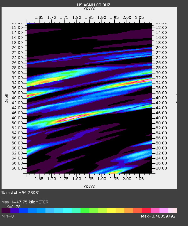
AGMN Agassiz National Wildlife Refuge, Minnesota, USA - Earthquake Result Viewer

Earthquake location: Off East Coast Of Honshu, Japan
Earthquake latitude/longitude: 38.0/143.3
Earthquake time(UTC): 2011/07/10 (191) 00:57:10 GMT
Earthquake Depth: 23 km
Earthquake Magnitude: 6.6 MB, 7.0 MS, 7.0 MW, 7.0 MW
Earthquake Catalog/Contributor: WHDF/NEIC
Network: US United States National Seismic Network
Station: AGMN Agassiz National Wildlife Refuge, Minnesota, USA
Lat/Lon: 48.30 N/95.86 W
Elevation: 351 m
Distance: 79.3 deg
Az: 35.685 deg
Baz: 316.385 deg
Ray Param: 0.049050007
Estimated Moho Depth: 47.75 km
Estimated Crust Vp/Vs: 1.78
Assumed Crust Vp: 6.419 km/s
Estimated Crust Vs: 3.606 km/s
Estimated Crust Poisson's Ratio: 0.27
Radial Match: 96.23031 %
Radial Bump: 345
Transverse Match: 87.86679 %
Transverse Bump: 400
SOD ConfigId: 558545
Insert Time: 2013-09-18 21:55:41.319 +0000
GWidth: 2.5
Max Bumps: 400
Tol: 0.001

Signal To Noise

ChannelStoNSTALTA
US:AGMN:00:BHZ:20110710T01:08:42.950024Z23.729381.971403E-68.3078575E-8
US:AGMN:00:BH1:20110710T01:08:42.950024Z8.00725656.419836E-78.017523E-8
US:AGMN:00:BH2:20110710T01:08:42.950024Z6.0473236.6888487E-71.10608426E-7
Arrivals
Ps6.0 SECOND
PpPs20 SECOND
PsPs/PpSs26 SECOND