You are here: Home > Network List > US - United States National Seismic Network Stations List
> Station DGMT Dagmar, Montana, USA > Earthquake Result Viewer
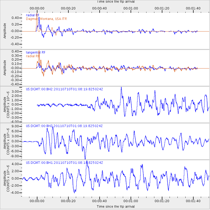
DGMT Dagmar, Montana, USA - Earthquake Result Viewer
*The percent match for this event was below the threshold and hence no stack was calculated.
| Earthquake location: |
Off East Coast Of Honshu, Japan |
| Earthquake latitude/longitude: |
38.0/143.3 |
| Earthquake time(UTC): |
2011/07/10 (191) 00:57:10 GMT |
| Earthquake Depth: |
23 km |
| Earthquake Magnitude: |
6.6 MB, 7.0 MS, 7.0 MW, 7.0 MW |
| Earthquake Catalog/Contributor: |
WHDF/NEIC |
|
| Network: |
US United States National Seismic Network |
| Station: |
DGMT Dagmar, Montana, USA |
| Lat/Lon: |
48.47 N/104.20 W |
| Elevation: |
0.0 m |
|
| Distance: |
75.1 deg |
| Az: |
39.49 deg |
| Baz: |
311.012 deg |
| Ray Param: |
$rayparam |
*The percent match for this event was below the threshold and hence was not used in the summary stack. |
|
| Radial Match: |
93.5625 % |
| Radial Bump: |
354 |
| Transverse Match: |
84.92402 % |
| Transverse Bump: |
400 |
| SOD ConfigId: |
558545 |
| Insert Time: |
2013-09-18 21:56:05.648 +0000 |
| GWidth: |
2.5 |
| Max Bumps: |
400 |
| Tol: |
0.001 |
|
Signal To Noise
| Channel | StoN | STA | LTA |
| US:DGMT:00:BHZ:20110710T01:08:19.825024Z | 16.398659 | 2.185028E-6 | 1.332443E-7 |
| US:DGMT:00:BH1:20110710T01:08:19.825024Z | 2.0168788 | 4.0028516E-7 | 1.9846763E-7 |
| US:DGMT:00:BH2:20110710T01:08:19.825024Z | 2.0516644 | 3.1963742E-7 | 1.557942E-7 |
| Arrivals |
| Ps | |
| PpPs | |
| PsPs/PpSs | |


