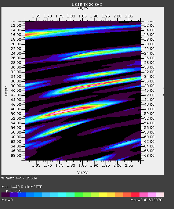
MNTX Cornudas Mountains, Texas, USA - Earthquake Result Viewer

Earthquake location: Off East Coast Of Honshu, Japan
Earthquake latitude/longitude: 38.0/143.3
Earthquake time(UTC): 2011/07/10 (191) 00:57:10 GMT
Earthquake Depth: 23 km
Earthquake Magnitude: 6.6 MB, 7.0 MS, 7.0 MW, 7.0 MW
Earthquake Catalog/Contributor: WHDF/NEIC
Network: US United States National Seismic Network
Station: MNTX Cornudas Mountains, Texas, USA
Lat/Lon: 31.70 N/105.38 W
Elevation: 404 m
Distance: 85.7 deg
Az: 52.765 deg
Baz: 312.476 deg
Ray Param: 0.04458442
Estimated Moho Depth: 49.0 km
Estimated Crust Vp/Vs: 1.75
Assumed Crust Vp: 6.361 km/s
Estimated Crust Vs: 3.624 km/s
Estimated Crust Poisson's Ratio: 0.26
Radial Match: 97.35504 %
Radial Bump: 400
Transverse Match: 85.943085 %
Transverse Bump: 400
SOD ConfigId: 558545
Insert Time: 2013-09-18 21:56:56.733 +0000
GWidth: 2.5
Max Bumps: 400
Tol: 0.001

Signal To Noise

ChannelStoNSTALTA
US:MNTX:00:BHZ:20110710T01:09:16.099011Z10.9379625.5032905E-75.0313677E-8
US:MNTX:00:BH1:20110710T01:09:16.099011Z1.96155151.2789283E-76.5199835E-8
US:MNTX:00:BH2:20110710T01:09:16.099011Z1.95681921.4514438E-77.417363E-8
Arrivals
Ps6.0 SECOND
PpPs21 SECOND
PsPs/PpSs27 SECOND