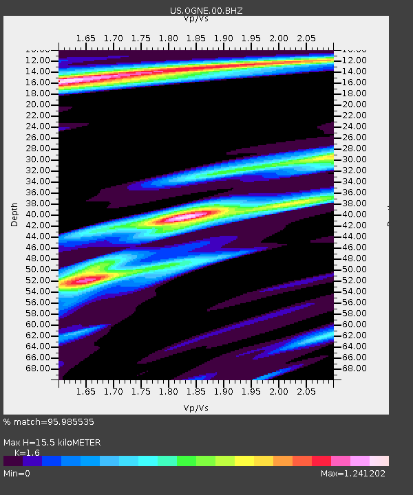
OGNE Ogallala, Nebraska, USA - Earthquake Result Viewer
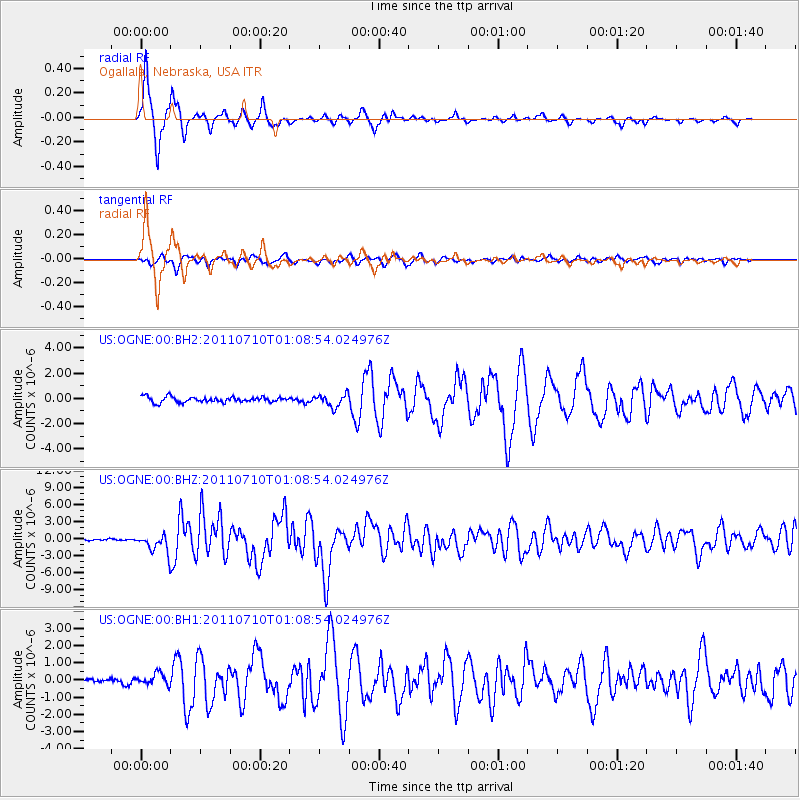
Earthquake location: Off East Coast Of Honshu, Japan
Earthquake latitude/longitude: 38.0/143.3
Earthquake time(UTC): 2011/07/10 (191) 00:57:10 GMT
Earthquake Depth: 23 km
Earthquake Magnitude: 6.6 MB, 7.0 MS, 7.0 MW, 7.0 MW
Earthquake Catalog/Contributor: WHDF/NEIC
Network: US United States National Seismic Network
Station: OGNE Ogallala, Nebraska, USA
Lat/Lon: 40.95 N/102.03 W
Elevation: 0.0 m
Distance: 81.3 deg
Az: 44.117 deg
Baz: 313.477 deg
Ray Param: 0.047630697
Estimated Moho Depth: 15.5 km
Estimated Crust Vp/Vs: 1.60
Assumed Crust Vp: 6.483 km/s
Estimated Crust Vs: 4.052 km/s
Estimated Crust Poisson's Ratio: 0.18
Radial Match: 95.985535 %
Radial Bump: 258
Transverse Match: 82.45498 %
Transverse Bump: 400
SOD ConfigId: 558545
Insert Time: 2013-09-18 21:57:13.626 +0000
GWidth: 2.5
Max Bumps: 400
Tol: 0.001

Signal To Noise

ChannelStoNSTALTA
US:OGNE:00:BHZ:20110710T01:08:54.024976Z11.91751.5955155E-61.3388006E-7
US:OGNE:00:BH1:20110710T01:08:54.024976Z1.86834363.3658583E-71.80152E-7
US:OGNE:00:BH2:20110710T01:08:54.024976Z2.3249564.966643E-72.1362311E-7
Arrivals
Ps1.5 SECOND
PpPs6.0 SECOND
PsPs/PpSs7.5 SECOND