You are here: Home > Network List > CN - Canadian National Seismograph Network Stations List
> Station INK INUVIK, NT, CANADA.ANADA > Earthquake Result Viewer
INK INUVIK, NT, CANADA.ANADA - Earthquake Result Viewer
| Earthquake location: |
Southeast Of Taiwan |
| Earthquake latitude/longitude: |
22.3/125.3 |
| Earthquake time(UTC): |
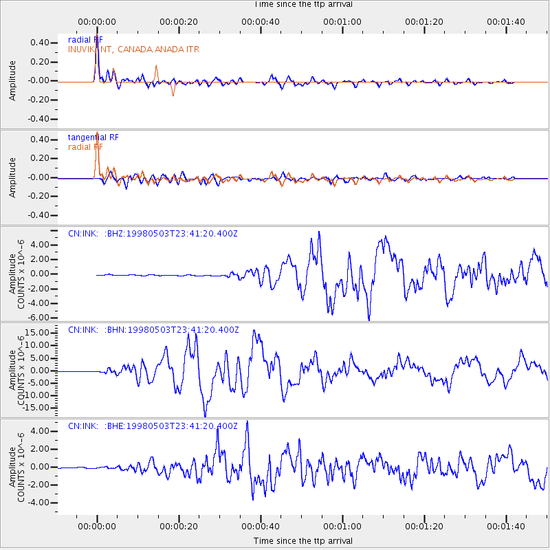
1998/05/03 (123) 23:30:21 GMT |
| Earthquake Depth: |
33 km |
| Earthquake Magnitude: |
6.4 MB, 7.3 MS, 7.5 UNKNOWN, 7.5 ME |
| Earthquake Catalog/Contributor: |
WHDF/NEIC |
|
| Network: |
CN Canadian National Seismograph Network |
| Station: |
INK INUVIK, NT, CANADA.ANADA |
| Lat/Lon: |
68.31 N/133.52 W |
| Elevation: |
40 m |
|
| Distance: |
73.5 deg |
| Az: |
22.356 deg |
| Baz: |
288.664 deg |
| Ray Param: |
0.05289866 |
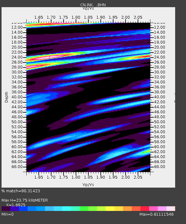
| Estimated Moho Depth: |
23.75 km |
| Estimated Crust Vp/Vs: |
1.69 |
| Assumed Crust Vp: |
6.171 km/s |
| Estimated Crust Vs: |
3.646 km/s |
| Estimated Crust Poisson's Ratio: |
0.23 |
|
| Radial Match: |
98.31423 % |
| Radial Bump: |
400 |
| Transverse Match: |
94.80123 % |
| Transverse Bump: |
400 |
| SOD ConfigId: |
4480 |
| Insert Time: |
2010-02-27 06:09:37.164 +0000 |
| GWidth: |
2.5 |
| Max Bumps: |
400 |
| Tol: |
0.001 |
|
Signal To Noise
| Channel | StoN | STA | LTA |
| CN:INK: :BHN:19980503T23:41:20.400Z | 5.179213 | 6.55023E-7 | 1.2647153E-7 |
| CN:INK: :BHE:19980503T23:41:20.400Z | 1.0503567 | 7.1896196E-8 | 6.844931E-8 |
| CN:INK: :BHZ:19980503T23:41:20.400Z | 3.7393663 | 2.2066588E-7 | 5.901157E-8 |
| Arrivals |
| Ps | 2.8 SECOND |
| PpPs | 10 SECOND |
| PsPs/PpSs | 13 SECOND |


