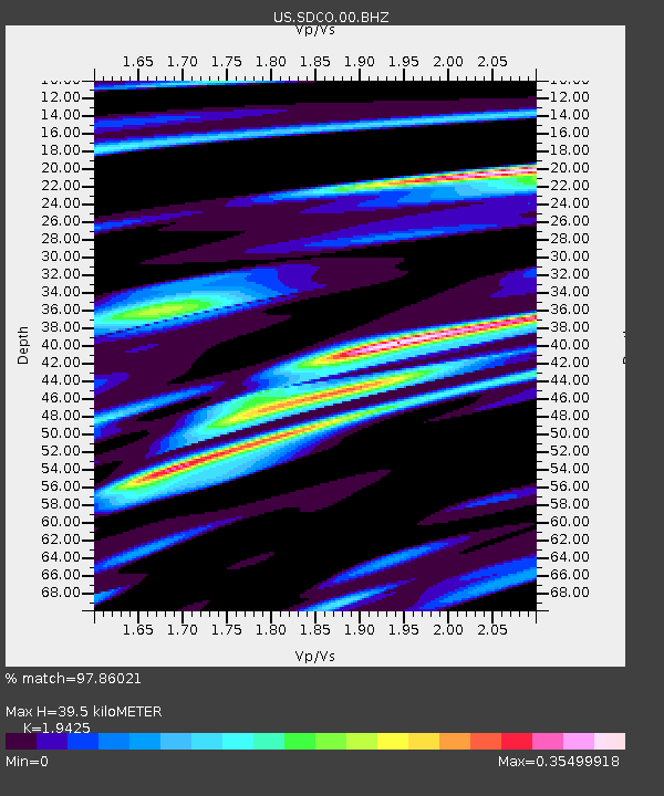
SDCO Great Sand Dunes National Park, Colorado, USA - Earthquake Result Viewer

Earthquake location: Off East Coast Of Honshu, Japan
Earthquake latitude/longitude: 38.0/143.3
Earthquake time(UTC): 2011/07/10 (191) 00:57:10 GMT
Earthquake Depth: 23 km
Earthquake Magnitude: 6.6 MB, 7.0 MS, 7.0 MW, 7.0 MW
Earthquake Catalog/Contributor: WHDF/NEIC
Network: US United States National Seismic Network
Station: SDCO Great Sand Dunes National Park, Colorado, USA
Lat/Lon: 37.75 N/105.50 W
Elevation: 2569 m
Distance: 81.5 deg
Az: 48.335 deg
Baz: 311.914 deg
Ray Param: 0.04749778
Estimated Moho Depth: 39.5 km
Estimated Crust Vp/Vs: 1.94
Assumed Crust Vp: 6.316 km/s
Estimated Crust Vs: 3.251 km/s
Estimated Crust Poisson's Ratio: 0.32
Radial Match: 97.86021 %
Radial Bump: 267
Transverse Match: 93.368225 %
Transverse Bump: 400
SOD ConfigId: 558545
Insert Time: 2013-09-18 21:57:27.986 +0000
GWidth: 2.5
Max Bumps: 400
Tol: 0.001

Signal To Noise

ChannelStoNSTALTA
US:SDCO:00:BHZ:20110710T01:08:55.024976Z14.43816958.2847777E-75.738108E-8
US:SDCO:00:BH1:20110710T01:08:55.024976Z2.46844559.910669E-84.0149438E-8
US:SDCO:00:BH2:20110710T01:08:55.024976Z6.2772652.4645925E-73.9262204E-8
Arrivals
Ps6.0 SECOND
PpPs18 SECOND
PsPs/PpSs24 SECOND