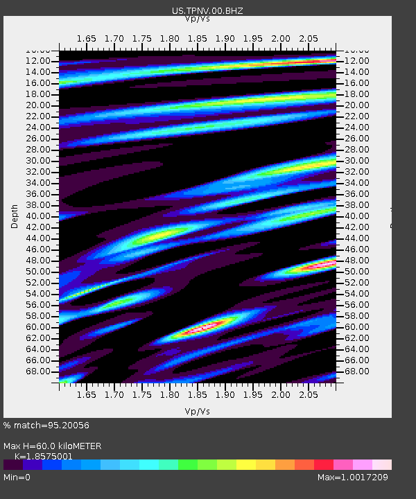
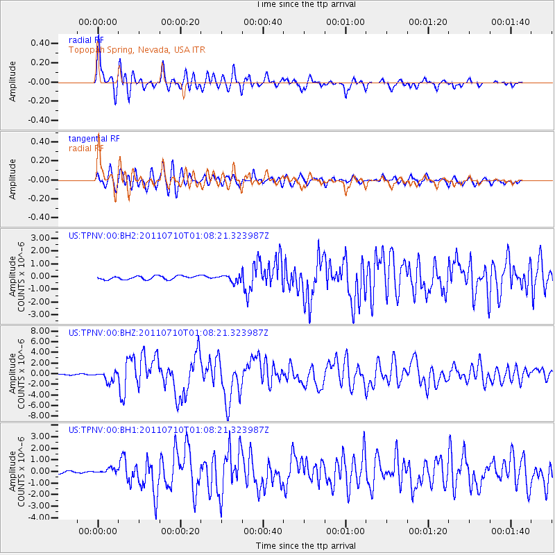
TPNV Topopah Spring, Nevada, USA - Earthquake Result Viewer

Earthquake location: Off East Coast Of Honshu, Japan
Earthquake latitude/longitude: 38.0/143.3
Earthquake time(UTC): 2011/07/10 (191) 00:57:10 GMT
Earthquake Depth: 23 km
Earthquake Magnitude: 6.6 MB, 7.0 MS, 7.0 MW, 7.0 MW
Earthquake Catalog/Contributor: WHDF/NEIC
Network: US United States National Seismic Network
Station: TPNV Topopah Spring, Nevada, USA
Lat/Lon: 36.95 N/116.25 W
Elevation: 1600 m
Distance: 75.4 deg
Az: 54.49 deg
Baz: 306.643 deg
Ray Param: 0.05167015
Estimated Moho Depth: 60.0 km
Estimated Crust Vp/Vs: 1.86
Assumed Crust Vp: 6.279 km/s
Estimated Crust Vs: 3.38 km/s
Estimated Crust Poisson's Ratio: 0.30
Radial Match: 95.20056 %
Radial Bump: 400
Transverse Match: 90.81904 %
Transverse Bump: 400
SOD ConfigId: 558545
Insert Time: 2013-09-18 21:57:31.723 +0000
GWidth: 2.5
Max Bumps: 400
Tol: 0.001

Signal To Noise

ChannelStoNSTALTA
US:TPNV:00:BHZ:20110710T01:08:21.323987Z7.78185039.720357E-71.2491061E-7
US:TPNV:00:BH1:20110710T01:08:21.323987Z1.66298082.6692544E-71.6051024E-7
US:TPNV:00:BH2:20110710T01:08:21.323987Z1.97699512.72928E-71.3805193E-7
Arrivals
Ps8.4 SECOND
PpPs27 SECOND
PsPs/PpSs35 SECOND