WMOK Wichita Mountains, Oklahoma, USA - Earthquake Result Viewer
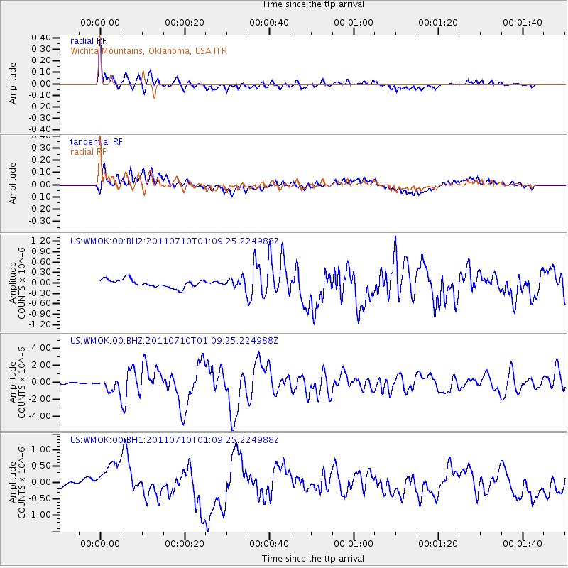
Earthquake location: Off East Coast Of Honshu, Japan
Earthquake latitude/longitude: 38.0/143.3
Earthquake time(UTC): 2011/07/10 (191) 00:57:10 GMT
Earthquake Depth: 23 km
Earthquake Magnitude: 6.6 MB, 7.0 MS, 7.0 MW, 7.0 MW
Earthquake Catalog/Contributor: WHDF/NEIC
Network: US United States National Seismic Network
Station: WMOK Wichita Mountains, Oklahoma, USA
Lat/Lon: 34.74 N/98.78 W
Elevation: 486 m
Distance: 87.5 deg
Az: 46.73 deg
Baz: 315.72 deg
Ray Param: 0.04324186
Estimated Moho Depth: 14.0 km
Estimated Crust Vp/Vs: 1.81
Assumed Crust Vp: 6.315 km/s
Estimated Crust Vs: 3.489 km/s
Estimated Crust Poisson's Ratio: 0.28
Radial Match: 94.608246 %
Radial Bump: 400
Transverse Match: 76.71831 %
Transverse Bump: 400
SOD ConfigId: 558545
Insert Time: 2013-09-18 21:57:41.094 +0000
GWidth: 2.5
Max Bumps: 400
Tol: 0.001

Signal To Noise

ChannelStoNSTALTA
US:WMOK:00:BHZ:20110710T01:09:25.224988Z7.82220276.7446103E-78.622393E-8
US:WMOK:00:BH1:20110710T01:09:25.224988Z1.82411744.4275748E-72.427242E-7
US:WMOK:00:BH2:20110710T01:09:25.224988Z1.27232311.45763E-71.1456444E-7
Arrivals
Ps1.8 SECOND
PpPs6.1 SECOND
PsPs/PpSs7.9 SECOND