You are here: Home > Network List > US - United States National Seismic Network Stations List
> Station WRAK Wrangell Island, Southeastern Alaska, Alaska, USA > Earthquake Result Viewer
WRAK Wrangell Island, Southeastern Alaska, Alaska, USA - Earthquake Result Viewer
| Earthquake location: |
Off East Coast Of Honshu, Japan |
| Earthquake latitude/longitude: |
38.0/143.3 |
| Earthquake time(UTC): |
2011/07/10 (191) 00:57:10 GMT |
| Earthquake Depth: |
23 km |
| Earthquake Magnitude: |
6.6 MB, 7.0 MS, 7.0 MW, 7.0 MW |
| Earthquake Catalog/Contributor: |
WHDF/NEIC |
|
| Network: |
US United States National Seismic Network |
| Station: |
WRAK Wrangell Island, Southeastern Alaska, Alaska, USA |
| Lat/Lon: |
56.42 N/132.35 W |
| Elevation: |
81 m |
|
| Distance: |
56.4 deg |
| Az: |
41.587 deg |
| Baz: |
289.401 deg |
| Ray Param: |
0.064117804 |
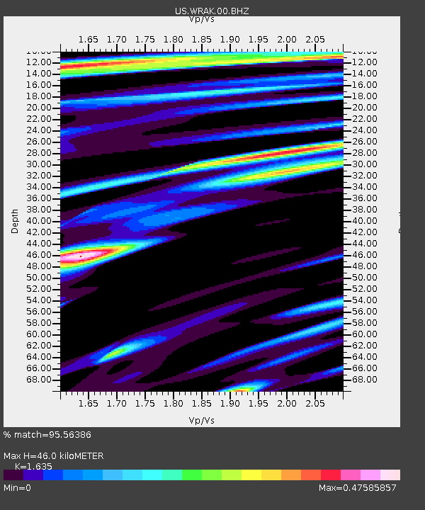
| Estimated Moho Depth: |
46.0 km |
| Estimated Crust Vp/Vs: |
1.63 |
| Assumed Crust Vp: |
6.597 km/s |
| Estimated Crust Vs: |
4.035 km/s |
| Estimated Crust Poisson's Ratio: |
0.20 |
|
| Radial Match: |
95.56386 % |
| Radial Bump: |
400 |
| Transverse Match: |
84.63874 % |
| Transverse Bump: |
400 |
| SOD ConfigId: |
558545 |
| Insert Time: |
2013-09-18 21:57:43.443 +0000 |
| GWidth: |
2.5 |
| Max Bumps: |
400 |
| Tol: |
0.001 |
|

Signal To Noise
| Channel | StoN | STA | LTA |
| US:WRAK:00:BHZ:20110710T01:06:19.549023Z | 14.093904 | 1.7653842E-6 | 1.2525871E-7 |
| US:WRAK:00:BH1:20110710T01:06:19.549023Z | 5.909287 | 4.0659262E-7 | 6.88057E-8 |
| US:WRAK:00:BH2:20110710T01:06:19.549023Z | 6.798805 | 7.5739337E-7 | 1.1140095E-7 |
| Arrivals |
| Ps | 4.7 SECOND |
| PpPs | 17 SECOND |
| PsPs/PpSs | 22 SECOND |


