You are here: Home > Network List > IU - Global Seismograph Network (GSN - IRIS/USGS) Stations List
> Station MAJO Matsushiro, Japan > Earthquake Result Viewer
MAJO Matsushiro, Japan - Earthquake Result Viewer
| Earthquake location: |
Kermadec Islands Region |
| Earthquake latitude/longitude: |
-29.5/-176.6 |
| Earthquake time(UTC): |
2011/07/11 (192) 07:15:43 GMT |
| Earthquake Depth: |
11 km |
| Earthquake Magnitude: |
5.5 MB, 6.0 MS, 6.1 MW, 5.9 MW |
| Earthquake Catalog/Contributor: |
WHDF/NEIC |
|
| Network: |
IU Global Seismograph Network (GSN - IRIS/USGS) |
| Station: |
MAJO Matsushiro, Japan |
| Lat/Lon: |
36.55 N/138.20 E |
| Elevation: |
405 m |
|
| Distance: |
78.2 deg |
| Az: |
324.276 deg |
| Baz: |
140.79 deg |
| Ray Param: |
0.049791515 |
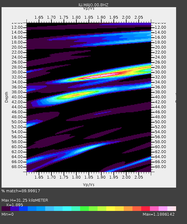
| Estimated Moho Depth: |
31.25 km |
| Estimated Crust Vp/Vs: |
1.89 |
| Assumed Crust Vp: |
6.461 km/s |
| Estimated Crust Vs: |
3.41 km/s |
| Estimated Crust Poisson's Ratio: |
0.31 |
|
| Radial Match: |
89.99917 % |
| Radial Bump: |
370 |
| Transverse Match: |
78.37507 % |
| Transverse Bump: |
400 |
| SOD ConfigId: |
558545 |
| Insert Time: |
2013-09-18 22:00:59.937 +0000 |
| GWidth: |
2.5 |
| Max Bumps: |
400 |
| Tol: |
0.001 |
|

Signal To Noise
| Channel | StoN | STA | LTA |
| IU:MAJO:00:BHZ:20110711T07:27:11.918977Z | 6.3069115 | 4.1162588E-7 | 6.5265844E-8 |
| IU:MAJO:00:BH1:20110711T07:27:11.918977Z | 2.2796123 | 1.4752305E-7 | 6.47141E-8 |
| IU:MAJO:00:BH2:20110711T07:27:11.918977Z | 1.0400326 | 5.9080577E-8 | 5.6806467E-8 |
| Arrivals |
| Ps | 4.5 SECOND |
| PpPs | 14 SECOND |
| PsPs/PpSs | 18 SECOND |


