You are here: Home > Network List > US - United States National Seismic Network Stations List
> Station BOZ Bozeman, Montana, USA > Earthquake Result Viewer
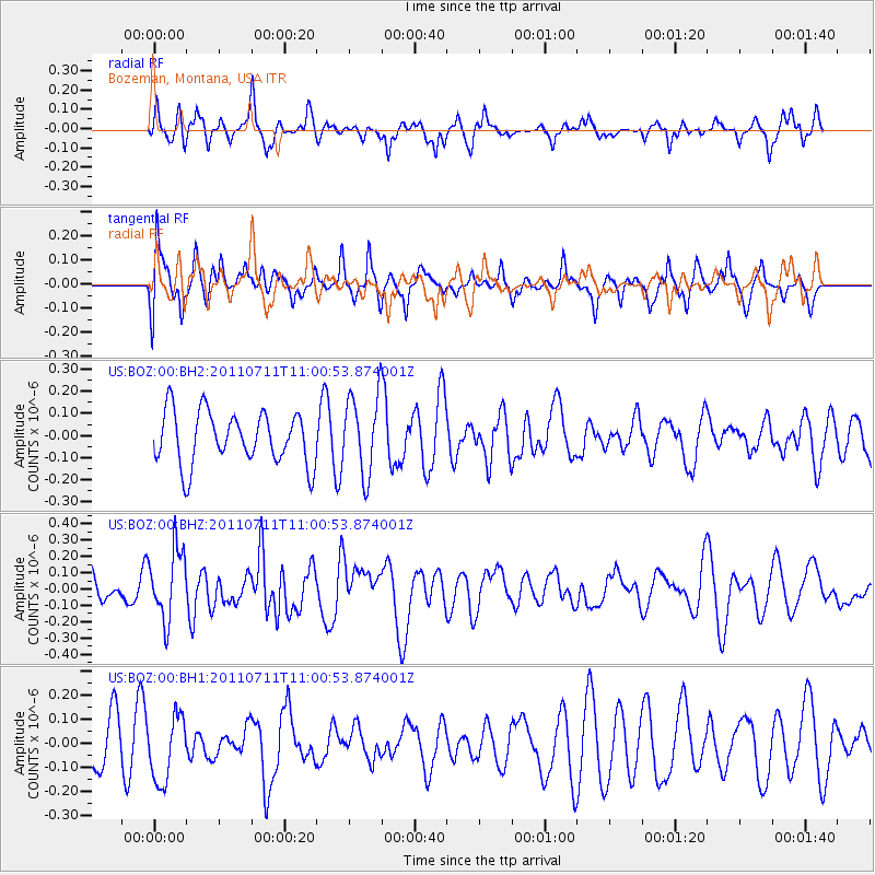
BOZ Bozeman, Montana, USA - Earthquake Result Viewer
*The percent match for this event was below the threshold and hence no stack was calculated.
| Earthquake location: |
Tonga Islands Region |
| Earthquake latitude/longitude: |
-22.7/-174.7 |
| Earthquake time(UTC): |
2011/07/11 (192) 10:48:32 GMT |
| Earthquake Depth: |
21 km |
| Earthquake Magnitude: |
5.6 MB, 5.4 MS, 5.6 MW, 5.6 MW |
| Earthquake Catalog/Contributor: |
WHDF/NEIC |
|
| Network: |
US United States National Seismic Network |
| Station: |
BOZ Bozeman, Montana, USA |
| Lat/Lon: |
45.65 N/111.63 W |
| Elevation: |
1589 m |
|
| Distance: |
88.9 deg |
| Az: |
38.74 deg |
| Baz: |
235.481 deg |
| Ray Param: |
$rayparam |
*The percent match for this event was below the threshold and hence was not used in the summary stack. |
|
| Radial Match: |
66.612404 % |
| Radial Bump: |
400 |
| Transverse Match: |
50.793777 % |
| Transverse Bump: |
387 |
| SOD ConfigId: |
558545 |
| Insert Time: |
2013-09-18 22:05:08.035 +0000 |
| GWidth: |
2.5 |
| Max Bumps: |
400 |
| Tol: |
0.001 |
|
Signal To Noise
| Channel | StoN | STA | LTA |
| US:BOZ:00:BHZ:20110711T11:00:53.874001Z | 1.9265331 | 2.140805E-7 | 1.11122155E-7 |
| US:BOZ:00:BH1:20110711T11:00:53.874001Z | 1.6252007 | 1.365703E-7 | 8.403289E-8 |
| US:BOZ:00:BH2:20110711T11:00:53.874001Z | 1.5729651 | 1.8654922E-7 | 1.1859717E-7 |
| Arrivals |
| Ps | |
| PpPs | |
| PsPs/PpSs | |


