You are here: Home > Network List > IU - Global Seismograph Network (GSN - IRIS/USGS) Stations List
> Station HNR Honiara, Solomon Islands > Earthquake Result Viewer
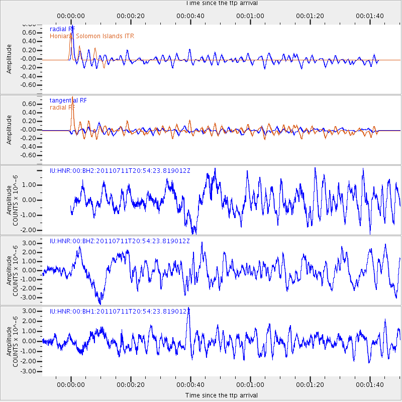
HNR Honiara, Solomon Islands - Earthquake Result Viewer
*The percent match for this event was below the threshold and hence no stack was calculated.
| Earthquake location: |
Negros, Philippines |
| Earthquake latitude/longitude: |
9.5/122.2 |
| Earthquake time(UTC): |
2011/07/11 (192) 20:47:04 GMT |
| Earthquake Depth: |
19 km |
| Earthquake Magnitude: |
6.1 MB, 6.1 MS, 6.4 MW, 6.2 MW |
| Earthquake Catalog/Contributor: |
WHDF/NEIC |
|
| Network: |
IU Global Seismograph Network (GSN - IRIS/USGS) |
| Station: |
HNR Honiara, Solomon Islands |
| Lat/Lon: |
9.44 S/159.95 E |
| Elevation: |
100 m |
|
| Distance: |
42.0 deg |
| Az: |
115.535 deg |
| Baz: |
295.56 deg |
| Ray Param: |
$rayparam |
*The percent match for this event was below the threshold and hence was not used in the summary stack. |
|
| Radial Match: |
70.1334 % |
| Radial Bump: |
400 |
| Transverse Match: |
60.057037 % |
| Transverse Bump: |
400 |
| SOD ConfigId: |
558545 |
| Insert Time: |
2013-09-18 22:09:31.434 +0000 |
| GWidth: |
2.5 |
| Max Bumps: |
400 |
| Tol: |
0.001 |
|
Signal To Noise
| Channel | StoN | STA | LTA |
| IU:HNR:00:BHZ:20110711T20:54:23.819012Z | 4.6062737 | 1.2885674E-6 | 2.7974184E-7 |
| IU:HNR:00:BH1:20110711T20:54:23.819012Z | 1.533472 | 6.112909E-7 | 3.9863193E-7 |
| IU:HNR:00:BH2:20110711T20:54:23.819012Z | 1.5070163 | 7.495981E-7 | 4.9740544E-7 |
| Arrivals |
| Ps | |
| PpPs | |
| PsPs/PpSs | |


