You are here: Home > Network List > TA - USArray Transportable Network (new EarthScope stations) Stations List
> Station D46A Sault St. Marie, ON, CAN > Earthquake Result Viewer
D46A Sault St. Marie, ON, CAN - Earthquake Result Viewer
| Earthquake location: |
Iceland |
| Earthquake latitude/longitude: |
64.7/-17.4 |
| Earthquake time(UTC): |
2014/09/05 (248) 01:19:36 GMT |
| Earthquake Depth: |
2.0 km |
| Earthquake Magnitude: |
5.3 MW |
| Earthquake Catalog/Contributor: |
ISC/ISC |
|
| Network: |
TA USArray Transportable Network (new EarthScope stations) |
| Station: |
D46A Sault St. Marie, ON, CAN |
| Lat/Lon: |
46.89 N/84.04 W |
| Elevation: |
353 m |
|
| Distance: |
39.3 deg |
| Az: |
276.068 deg |
| Baz: |
38.563 deg |
| Ray Param: |
0.07510307 |
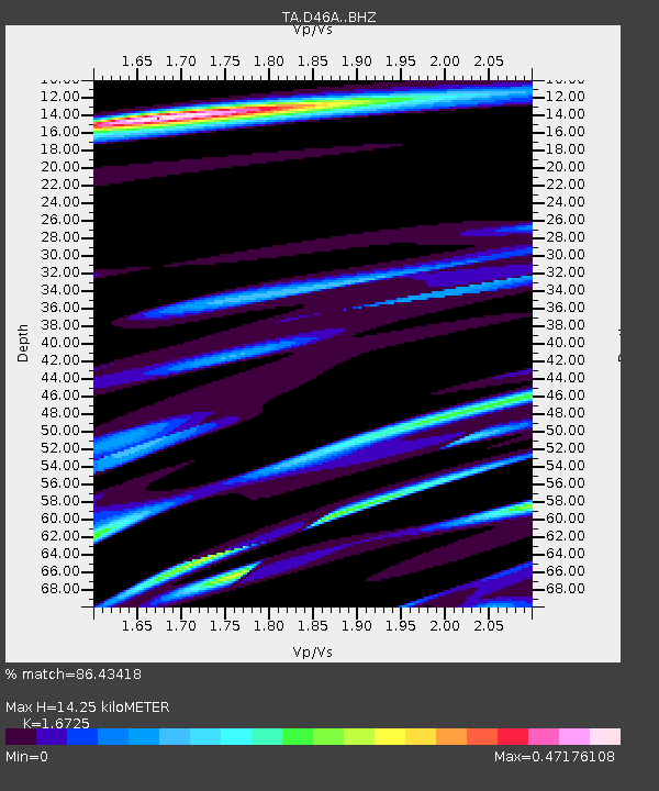
| Estimated Moho Depth: |
14.25 km |
| Estimated Crust Vp/Vs: |
1.67 |
| Assumed Crust Vp: |
6.467 km/s |
| Estimated Crust Vs: |
3.866 km/s |
| Estimated Crust Poisson's Ratio: |
0.22 |
|
| Radial Match: |
86.43418 % |
| Radial Bump: |
400 |
| Transverse Match: |
49.81764 % |
| Transverse Bump: |
335 |
| SOD ConfigId: |
3390531 |
| Insert Time: |
2019-04-13 20:51:04.830 +0000 |
| GWidth: |
2.5 |
| Max Bumps: |
400 |
| Tol: |
0.001 |
|
Signal To Noise
| Channel | StoN | STA | LTA |
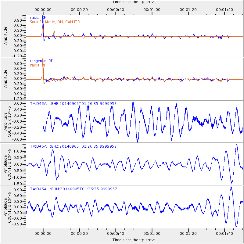
| TA:D46A: :BHZ:20140905T01:26:35.999995Z | 2.88669 | 4.470357E-7 | 1.5486101E-7 |
| TA:D46A: :BHN:20140905T01:26:35.999995Z | 1.2462622 | 1.9521055E-7 | 1.5663682E-7 |
| TA:D46A: :BHE:20140905T01:26:35.999995Z | 0.39181045 | 8.9938816E-8 | 2.2954676E-7 |
| Arrivals |
| Ps | 1.6 SECOND |
| PpPs | 5.5 SECOND |
| PsPs/PpSs | 7.1 SECOND |


