You are here: Home > Network List > US - United States National Seismic Network Stations List
> Station DGMT Dagmar, Montana, USA > Earthquake Result Viewer
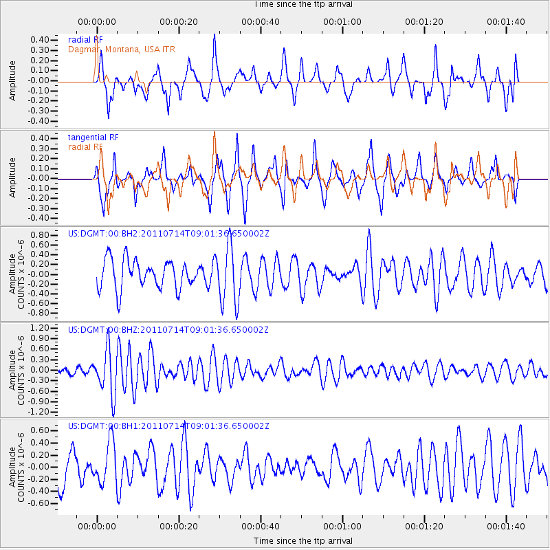
DGMT Dagmar, Montana, USA - Earthquake Result Viewer
*The percent match for this event was below the threshold and hence no stack was calculated.
| Earthquake location: |
West Chile Rise |
| Earthquake latitude/longitude: |
-38.2/-93.8 |
| Earthquake time(UTC): |
2011/07/14 (195) 08:49:23 GMT |
| Earthquake Depth: |
10 km |
| Earthquake Magnitude: |
5.5 MW |
| Earthquake Catalog/Contributor: |
NEIC PDE/NEIC PDE-M |
|
| Network: |
US United States National Seismic Network |
| Station: |
DGMT Dagmar, Montana, USA |
| Lat/Lon: |
48.47 N/104.20 W |
| Elevation: |
0.0 m |
|
| Distance: |
86.8 deg |
| Az: |
353.062 deg |
| Baz: |
171.781 deg |
| Ray Param: |
$rayparam |
*The percent match for this event was below the threshold and hence was not used in the summary stack. |
|
| Radial Match: |
60.277615 % |
| Radial Bump: |
400 |
| Transverse Match: |
55.580883 % |
| Transverse Bump: |
349 |
| SOD ConfigId: |
558545 |
| Insert Time: |
2013-09-18 22:16:12.913 +0000 |
| GWidth: |
2.5 |
| Max Bumps: |
400 |
| Tol: |
0.001 |
|
Signal To Noise
| Channel | StoN | STA | LTA |
| US:DGMT:00:BHZ:20110714T09:01:36.650002Z | 5.908884 | 6.522391E-7 | 1.1038279E-7 |
| US:DGMT:00:BH1:20110714T09:01:36.650002Z | 0.88340974 | 3.5141954E-7 | 3.9779903E-7 |
| US:DGMT:00:BH2:20110714T09:01:36.650002Z | 2.0671132 | 6.0397264E-7 | 2.9218168E-7 |
| Arrivals |
| Ps | |
| PpPs | |
| PsPs/PpSs | |


