You are here: Home > Network List > TA - USArray Transportable Network (new EarthScope stations) Stations List
> Station V55A Taylorsville, NC, USA > Earthquake Result Viewer
V55A Taylorsville, NC, USA - Earthquake Result Viewer
| Earthquake location: |
Iceland |
| Earthquake latitude/longitude: |
64.7/-17.4 |
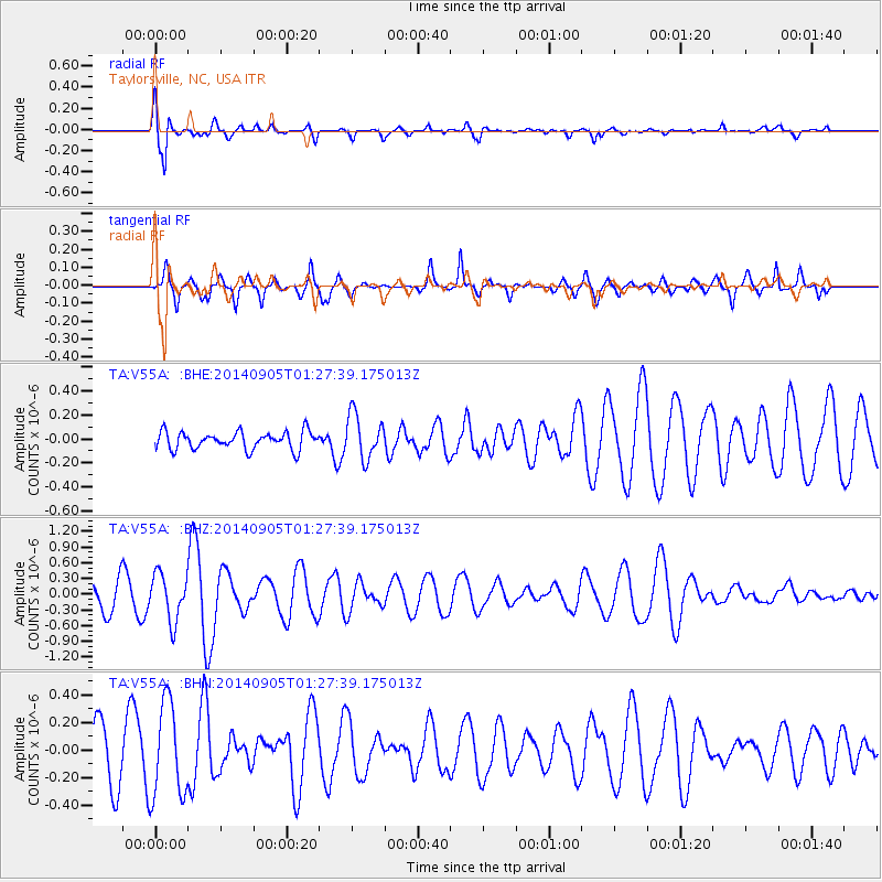
| Earthquake time(UTC): |
2014/09/05 (248) 01:19:36 GMT |
| Earthquake Depth: |
2.0 km |
| Earthquake Magnitude: |
5.3 MW |
| Earthquake Catalog/Contributor: |
ISC/ISC |
|
| Network: |
TA USArray Transportable Network (new EarthScope stations) |
| Station: |
V55A Taylorsville, NC, USA |
| Lat/Lon: |
35.85 N/81.21 W |
| Elevation: |
306 m |
|
| Distance: |
47.1 deg |
| Az: |
264.244 deg |
| Baz: |
31.773 deg |
| Ray Param: |
0.07024174 |
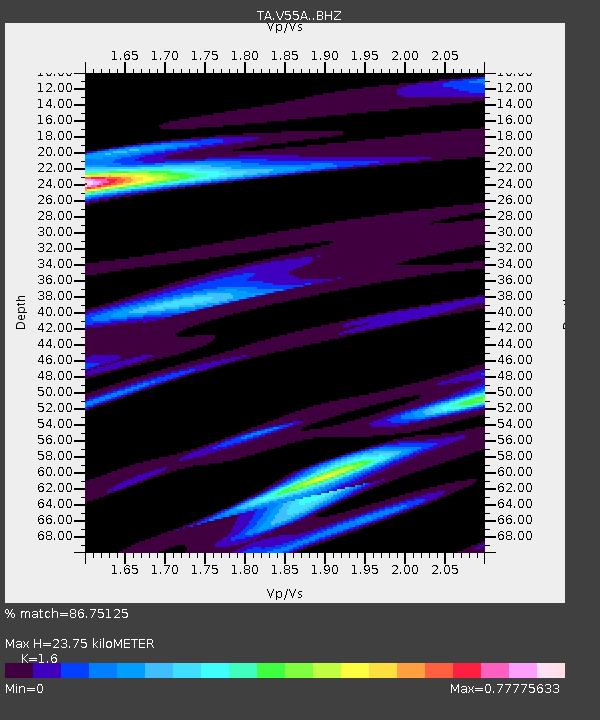
| Estimated Moho Depth: |
23.75 km |
| Estimated Crust Vp/Vs: |
1.60 |
| Assumed Crust Vp: |
6.419 km/s |
| Estimated Crust Vs: |
4.012 km/s |
| Estimated Crust Poisson's Ratio: |
0.18 |
|
| Radial Match: |
86.75125 % |
| Radial Bump: |
400 |
| Transverse Match: |
60.946175 % |
| Transverse Bump: |
338 |
| SOD ConfigId: |
3390531 |
| Insert Time: |
2019-04-13 20:51:57.850 +0000 |
| GWidth: |
2.5 |
| Max Bumps: |
400 |
| Tol: |
0.001 |
|
Signal To Noise
| Channel | StoN | STA | LTA |
| TA:V55A: :BHZ:20140905T01:27:39.175013Z | 1.7567042 | 4.4433932E-7 | 2.5293917E-7 |
| TA:V55A: :BHN:20140905T01:27:39.175013Z | 2.0856183 | 3.432911E-7 | 1.645992E-7 |
| TA:V55A: :BHE:20140905T01:27:39.175013Z | 2.5550928 | 1.8594594E-7 | 7.2774625E-8 |
| Arrivals |
| Ps | 2.4 SECOND |
| PpPs | 9.0 SECOND |
| PsPs/PpSs | 11 SECOND |


