You are here: Home > Network List > CN - Canadian National Seismograph Network Stations List
> Station INK INUVIK, N.W.T. > Earthquake Result Viewer
INK INUVIK, N.W.T. - Earthquake Result Viewer
| Earthquake location: |
Kamchatka Peninsula, Russia |
| Earthquake latitude/longitude: |
55.7/160.0 |
| Earthquake time(UTC): |
2004/06/10 (162) 15:19:57 GMT |
| Earthquake Depth: |
189 km |
| Earthquake Magnitude: |
6.1 MB, 6.9 MW, 6.9 MW |
| Earthquake Catalog/Contributor: |
WHDF/NEIC |
|
| Network: |
CN Canadian National Seismograph Network |
| Station: |
INK INUVIK, N.W.T. |
| Lat/Lon: |
68.31 N/133.52 W |
| Elevation: |
40 m |
|
| Distance: |
31.9 deg |
| Az: |
40.194 deg |
| Baz: |
280.534 deg |
| Ray Param: |
0.07831792 |
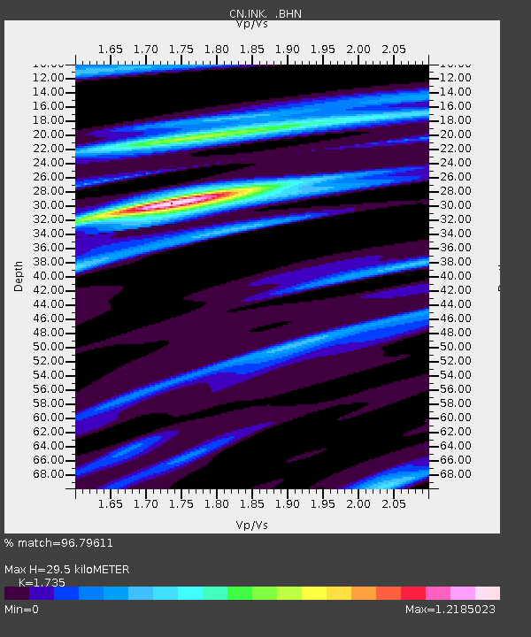
| Estimated Moho Depth: |
29.5 km |
| Estimated Crust Vp/Vs: |
1.74 |
| Assumed Crust Vp: |
6.171 km/s |
| Estimated Crust Vs: |
3.557 km/s |
| Estimated Crust Poisson's Ratio: |
0.25 |
|
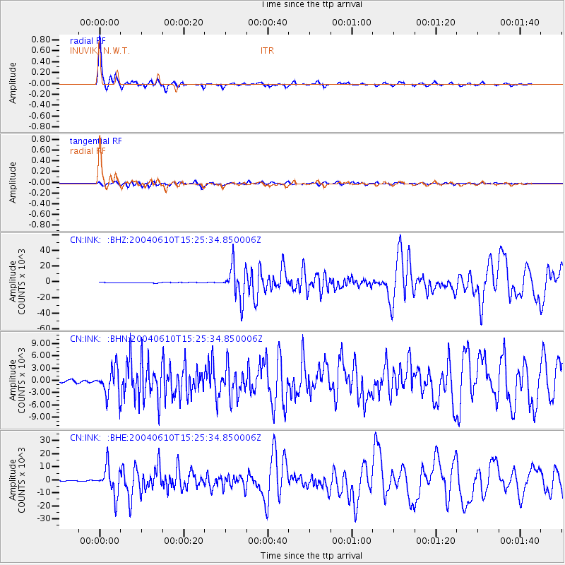
| Radial Match: |
96.79611 % |
| Radial Bump: |
292 |
| Transverse Match: |
88.72011 % |
| Transverse Bump: |
400 |
| SOD ConfigId: |
2459 |
| Insert Time: |
2010-02-27 06:10:16.524 +0000 |
| GWidth: |
2.5 |
| Max Bumps: |
400 |
| Tol: |
0.001 |
|
Signal To Noise
| Channel | StoN | STA | LTA |
| CN:INK: :BHN:20040610T15:25:34.850006Z | 13.959815 | 3335.45 | 238.93225 |
| CN:INK: :BHE:20040610T15:25:34.850006Z | 49.620583 | 11325.931 | 228.25066 |
| CN:INK: :BHZ:20040610T15:25:34.850006Z | 60.449936 | 21300.38 | 352.364 |
| Arrivals |
| Ps | 3.8 SECOND |
| PpPs | 12 SECOND |
| PsPs/PpSs | 16 SECOND |


