You are here: Home > Network List > IU - Global Seismograph Network (GSN - IRIS/USGS) Stations List
> Station MAJO Matsushiro, Japan > Earthquake Result Viewer
MAJO Matsushiro, Japan - Earthquake Result Viewer
*The percent match for this event was below the threshold and hence no stack was calculated.
| Earthquake location: |
South Of Tonga Islands |
| Earthquake latitude/longitude: |
-24.2/-175.3 |
| Earthquake time(UTC): |
2011/07/15 (196) 00:55:46 GMT |
| Earthquake Depth: |
38 km |
| Earthquake Magnitude: |
5.6 MB |
| Earthquake Catalog/Contributor: |
NEIC PDE/NEIC PDE-M |
|
| Network: |
IU Global Seismograph Network (GSN - IRIS/USGS) |
| Station: |
MAJO Matsushiro, Japan |
| Lat/Lon: |
36.55 N/138.20 E |
| Elevation: |
405 m |
|
| Distance: |
74.7 deg |
| Az: |
322.72 deg |
| Baz: |
136.617 deg |
| Ray Param: |
$rayparam |
*The percent match for this event was below the threshold and hence was not used in the summary stack. |
|
| Radial Match: |
52.22557 % |
| Radial Bump: |
400 |
| Transverse Match: |
54.97393 % |
| Transverse Bump: |
400 |
| SOD ConfigId: |
558545 |
| Insert Time: |
2013-09-18 22:22:16.514 +0000 |
| GWidth: |
2.5 |
| Max Bumps: |
400 |
| Tol: |
0.001 |
|
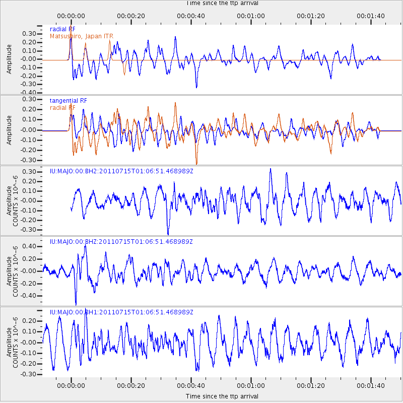
Signal To Noise
| Channel | StoN | STA | LTA |
| IU:MAJO:00:BHZ:20110715T01:06:51.468989Z | 3.1552668 | 2.2839346E-7 | 7.2384836E-8 |
| IU:MAJO:00:BH1:20110715T01:06:51.468989Z | 1.7311392 | 1.5135387E-7 | 8.743021E-8 |
| IU:MAJO:00:BH2:20110715T01:06:51.468989Z | 2.1008532 | 1.487192E-7 | 7.078991E-8 |
| Arrivals |
| Ps | |
| PpPs | |
| PsPs/PpSs | |


