You are here: Home > Network List > IU - Global Seismograph Network (GSN - IRIS/USGS) Stations List
> Station RSSD Black Hills, South Dakota, USA > Earthquake Result Viewer
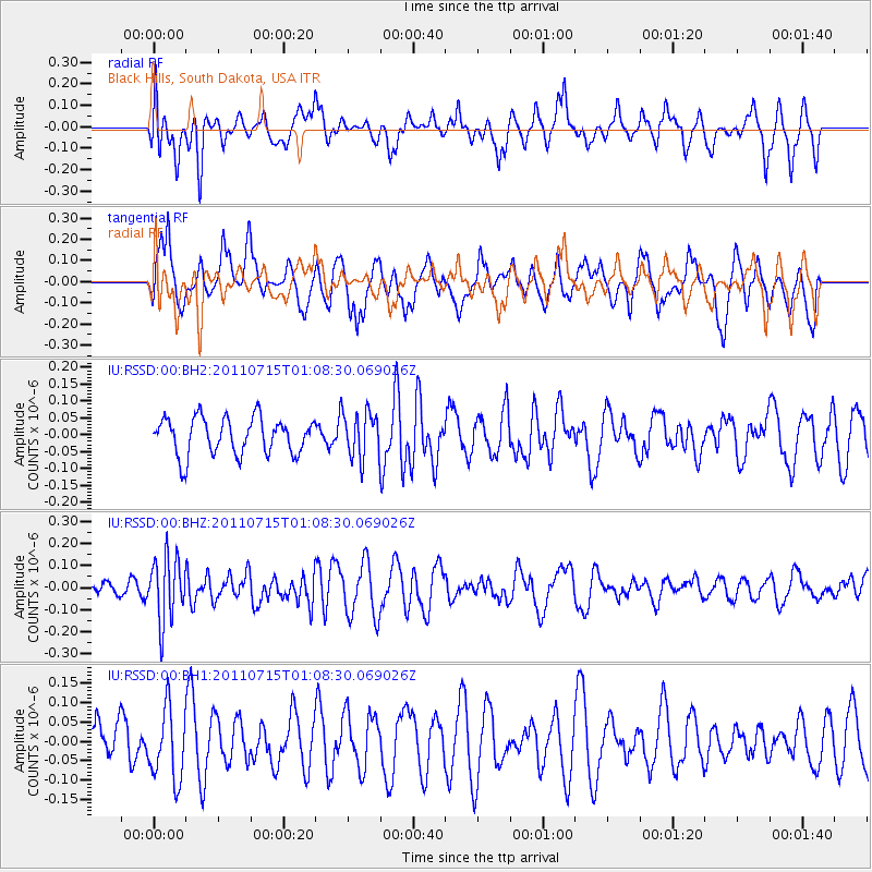
RSSD Black Hills, South Dakota, USA - Earthquake Result Viewer
*The percent match for this event was below the threshold and hence no stack was calculated.
| Earthquake location: |
South Of Tonga Islands |
| Earthquake latitude/longitude: |
-24.2/-175.3 |
| Earthquake time(UTC): |
2011/07/15 (196) 00:55:46 GMT |
| Earthquake Depth: |
38 km |
| Earthquake Magnitude: |
5.6 MB |
| Earthquake Catalog/Contributor: |
NEIC PDE/NEIC PDE-M |
|
| Network: |
IU Global Seismograph Network (GSN - IRIS/USGS) |
| Station: |
RSSD Black Hills, South Dakota, USA |
| Lat/Lon: |
44.12 N/104.04 W |
| Elevation: |
2090 m |
|
| Distance: |
94.1 deg |
| Az: |
43.139 deg |
| Baz: |
240.112 deg |
| Ray Param: |
$rayparam |
*The percent match for this event was below the threshold and hence was not used in the summary stack. |
|
| Radial Match: |
55.704983 % |
| Radial Bump: |
400 |
| Transverse Match: |
54.299953 % |
| Transverse Bump: |
400 |
| SOD ConfigId: |
558545 |
| Insert Time: |
2013-09-18 22:22:34.895 +0000 |
| GWidth: |
2.5 |
| Max Bumps: |
400 |
| Tol: |
0.001 |
|
Signal To Noise
| Channel | StoN | STA | LTA |
| IU:RSSD:00:BHZ:20110715T01:08:30.069026Z | 3.1923342 | 1.446021E-7 | 4.5296662E-8 |
| IU:RSSD:00:BH1:20110715T01:08:30.069026Z | 1.1894366 | 9.3673215E-8 | 7.8754276E-8 |
| IU:RSSD:00:BH2:20110715T01:08:30.069026Z | 1.2628158 | 6.8498665E-8 | 5.4242797E-8 |
| Arrivals |
| Ps | |
| PpPs | |
| PsPs/PpSs | |


