You are here: Home > Network List > US - United States National Seismic Network Stations List
> Station BOZ Bozeman, Montana, USA > Earthquake Result Viewer
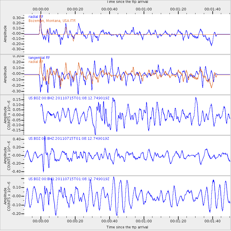
BOZ Bozeman, Montana, USA - Earthquake Result Viewer
*The percent match for this event was below the threshold and hence no stack was calculated.
| Earthquake location: |
South Of Tonga Islands |
| Earthquake latitude/longitude: |
-24.2/-175.3 |
| Earthquake time(UTC): |
2011/07/15 (196) 00:55:46 GMT |
| Earthquake Depth: |
38 km |
| Earthquake Magnitude: |
5.6 MB |
| Earthquake Catalog/Contributor: |
NEIC PDE/NEIC PDE-M |
|
| Network: |
US United States National Seismic Network |
| Station: |
BOZ Bozeman, Montana, USA |
| Lat/Lon: |
45.65 N/111.63 W |
| Elevation: |
1589 m |
|
| Distance: |
90.4 deg |
| Az: |
38.954 deg |
| Baz: |
234.929 deg |
| Ray Param: |
$rayparam |
*The percent match for this event was below the threshold and hence was not used in the summary stack. |
|
| Radial Match: |
58.851173 % |
| Radial Bump: |
400 |
| Transverse Match: |
57.556038 % |
| Transverse Bump: |
328 |
| SOD ConfigId: |
558545 |
| Insert Time: |
2013-09-18 22:22:54.774 +0000 |
| GWidth: |
2.5 |
| Max Bumps: |
400 |
| Tol: |
0.001 |
|
Signal To Noise
| Channel | StoN | STA | LTA |
| US:BOZ:00:BHZ:20110715T01:08:12.749019Z | 2.6343825 | 1.9289101E-7 | 7.3220576E-8 |
| US:BOZ:00:BH1:20110715T01:08:12.749019Z | 0.66543716 | 7.364288E-8 | 1.1066842E-7 |
| US:BOZ:00:BH2:20110715T01:08:12.749019Z | 2.1323004 | 9.5561035E-8 | 4.4815934E-8 |
| Arrivals |
| Ps | |
| PpPs | |
| PsPs/PpSs | |


