You are here: Home > Network List > II - Global Seismograph Network (GSN - IRIS/IDA) Stations List
> Station WRAB Tennant Creek, NT, Australia > Earthquake Result Viewer
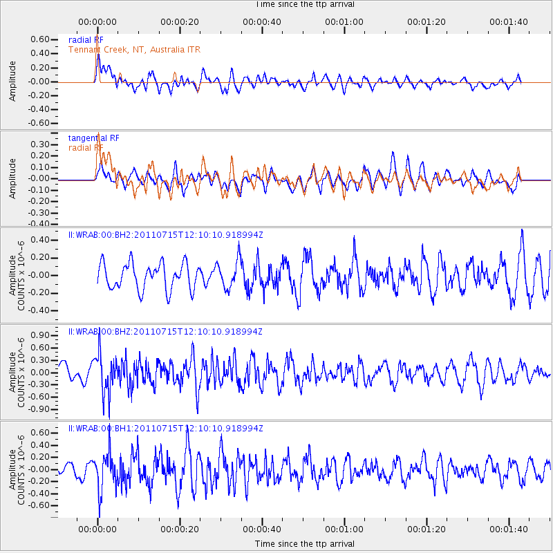
WRAB Tennant Creek, NT, Australia - Earthquake Result Viewer
*The percent match for this event was below the threshold and hence no stack was calculated.
| Earthquake location: |
Eastern Honshu, Japan |
| Earthquake latitude/longitude: |
36.1/139.9 |
| Earthquake time(UTC): |
2011/07/15 (196) 12:01:12 GMT |
| Earthquake Depth: |
89 km |
| Earthquake Magnitude: |
5.5 MW |
| Earthquake Catalog/Contributor: |
NEIC PDE/NEIC PDE-M |
|
| Network: |
II Global Seismograph Network (GSN - IRIS/IDA) |
| Station: |
WRAB Tennant Creek, NT, Australia |
| Lat/Lon: |
19.93 S/134.36 E |
| Elevation: |
366 m |
|
| Distance: |
56.0 deg |
| Az: |
186.233 deg |
| Baz: |
5.361 deg |
| Ray Param: |
$rayparam |
*The percent match for this event was below the threshold and hence was not used in the summary stack. |
|
| Radial Match: |
55.987682 % |
| Radial Bump: |
400 |
| Transverse Match: |
58.780796 % |
| Transverse Bump: |
400 |
| SOD ConfigId: |
558545 |
| Insert Time: |
2013-09-18 22:24:32.404 +0000 |
| GWidth: |
2.5 |
| Max Bumps: |
400 |
| Tol: |
0.001 |
|
Signal To Noise
| Channel | StoN | STA | LTA |
| II:WRAB:00:BHZ:20110715T12:10:10.918994Z | 2.3560815 | 4.8834966E-7 | 2.0727197E-7 |
| II:WRAB:00:BH1:20110715T12:10:10.918994Z | 1.4524446 | 3.1825508E-7 | 2.1911686E-7 |
| II:WRAB:00:BH2:20110715T12:10:10.918994Z | 1.117149 | 1.6303336E-7 | 1.45937E-7 |
| Arrivals |
| Ps | |
| PpPs | |
| PsPs/PpSs | |


