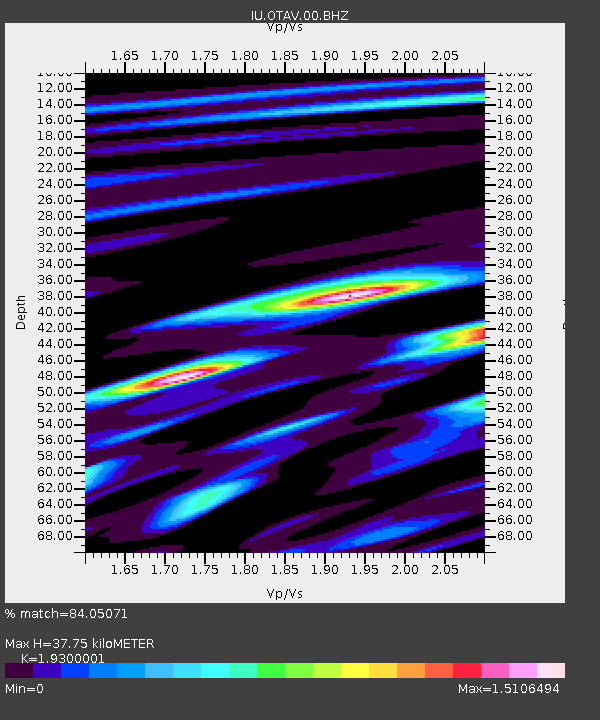
OTAV Otavalo, Ecuador - Earthquake Result Viewer
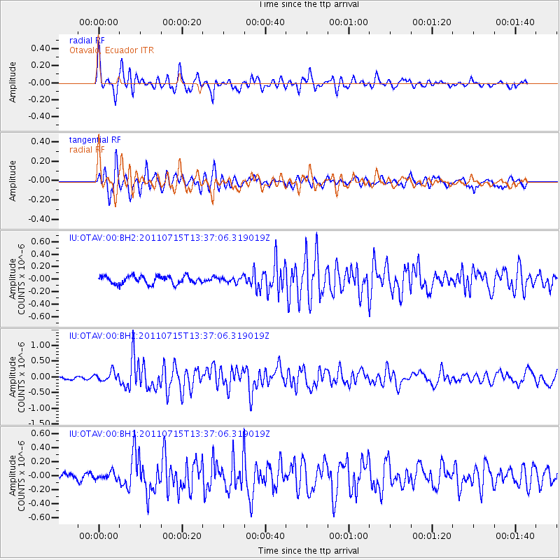
Earthquake location: South Sandwich Islands Region
Earthquake latitude/longitude: -60.8/-23.5
Earthquake time(UTC): 2011/07/15 (196) 13:26:02 GMT
Earthquake Depth: 10 km
Earthquake Magnitude: 5.7 MB, 5.6 MS, 6.2 MW, 6.1 MW
Earthquake Catalog/Contributor: WHDF/NEIC
Network: IU Global Seismograph Network (GSN - IRIS/USGS)
Station: OTAV Otavalo, Ecuador
Lat/Lon: 0.24 N/78.45 W
Elevation: 3510 m
Distance: 73.8 deg
Az: 301.555 deg
Baz: 155.269 deg
Ray Param: 0.052743003
Estimated Moho Depth: 37.75 km
Estimated Crust Vp/Vs: 1.93
Assumed Crust Vp: 6.472 km/s
Estimated Crust Vs: 3.353 km/s
Estimated Crust Poisson's Ratio: 0.32
Radial Match: 84.05071 %
Radial Bump: 400
Transverse Match: 89.424644 %
Transverse Bump: 400
SOD ConfigId: 558545
Insert Time: 2013-09-18 22:27:35.217 +0000
GWidth: 2.5
Max Bumps: 400
Tol: 0.001

Signal To Noise

ChannelStoNSTALTA
IU:OTAV:00:BHZ:20110715T13:37:06.319019Z3.01185131.5232672E-75.0575775E-8
IU:OTAV:00:BH1:20110715T13:37:06.319019Z0.66701635.1590987E-87.7345916E-8
IU:OTAV:00:BH2:20110715T13:37:06.319019Z0.68475654.286366E-86.259694E-8
Arrivals
Ps5.6 SECOND
PpPs17 SECOND
PsPs/PpSs22 SECOND