You are here: Home > Network List > US - United States National Seismic Network Stations List
> Station EGMT Eagleton, Montana, USA > Earthquake Result Viewer
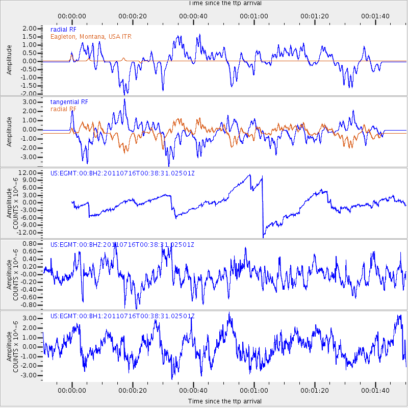
EGMT Eagleton, Montana, USA - Earthquake Result Viewer
*The percent match for this event was below the threshold and hence no stack was calculated.
| Earthquake location: |
Near Coast Of Central Chile |
| Earthquake latitude/longitude: |
-33.8/-71.8 |
| Earthquake time(UTC): |
2011/07/16 (197) 00:26:12 GMT |
| Earthquake Depth: |
20 km |
| Earthquake Magnitude: |
5.8 MB, 5.8 MS, 6.1 MW, 6.0 MW |
| Earthquake Catalog/Contributor: |
WHDF/NEIC |
|
| Network: |
US United States National Seismic Network |
| Station: |
EGMT Eagleton, Montana, USA |
| Lat/Lon: |
48.02 N/109.75 W |
| Elevation: |
1055 m |
|
| Distance: |
88.3 deg |
| Az: |
335.621 deg |
| Baz: |
149.209 deg |
| Ray Param: |
$rayparam |
*The percent match for this event was below the threshold and hence was not used in the summary stack. |
|
| Radial Match: |
74.17242 % |
| Radial Bump: |
400 |
| Transverse Match: |
70.30256 % |
| Transverse Bump: |
400 |
| SOD ConfigId: |
558545 |
| Insert Time: |
2013-09-18 22:30:46.791 +0000 |
| GWidth: |
2.5 |
| Max Bumps: |
400 |
| Tol: |
0.001 |
|
Signal To Noise
| Channel | StoN | STA | LTA |
| US:EGMT:00:BHZ:20110716T00:38:31.02501Z | 1.8942248 | 3.306422E-7 | 1.7455278E-7 |
| US:EGMT:00:BH1:20110716T00:38:31.02501Z | 1.881832 | 1.6861511E-6 | 8.960157E-7 |
| US:EGMT:00:BH2:20110716T00:38:31.02501Z | 1.9952502 | 3.891906E-6 | 1.9505856E-6 |
| Arrivals |
| Ps | |
| PpPs | |
| PsPs/PpSs | |


