You are here: Home > Network List > IU - Global Seismograph Network (GSN - IRIS/USGS) Stations List
> Station HNR Honiara, Solomon Islands > Earthquake Result Viewer
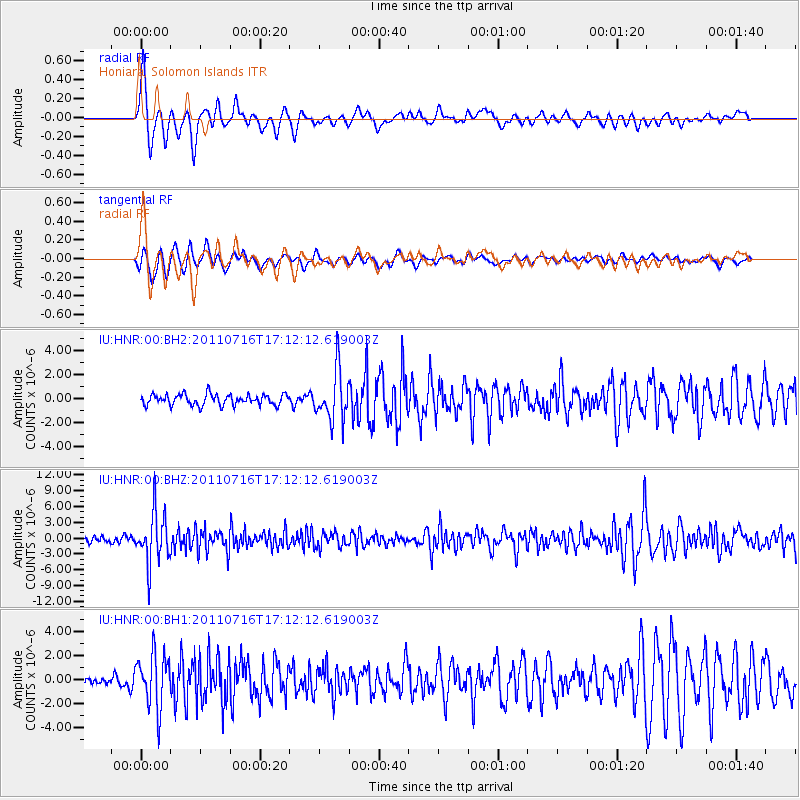
HNR Honiara, Solomon Islands - Earthquake Result Viewer
| Earthquake location: |
Banda Sea |
| Earthquake latitude/longitude: |
-7.1/127.6 |
| Earthquake time(UTC): |
2011/07/16 (197) 17:06:39 GMT |
| Earthquake Depth: |
255 km |
| Earthquake Magnitude: |
5.8 MB, 5.9 MW, 5.9 MW |
| Earthquake Catalog/Contributor: |
WHDF/NEIC |
|
| Network: |
IU Global Seismograph Network (GSN - IRIS/USGS) |
| Station: |
HNR Honiara, Solomon Islands |
| Lat/Lon: |
9.44 S/159.95 E |
| Elevation: |
100 m |
|
| Distance: |
32.1 deg |
| Az: |
96.413 deg |
| Baz: |
271.662 deg |
| Ray Param: |
0.07795871 |
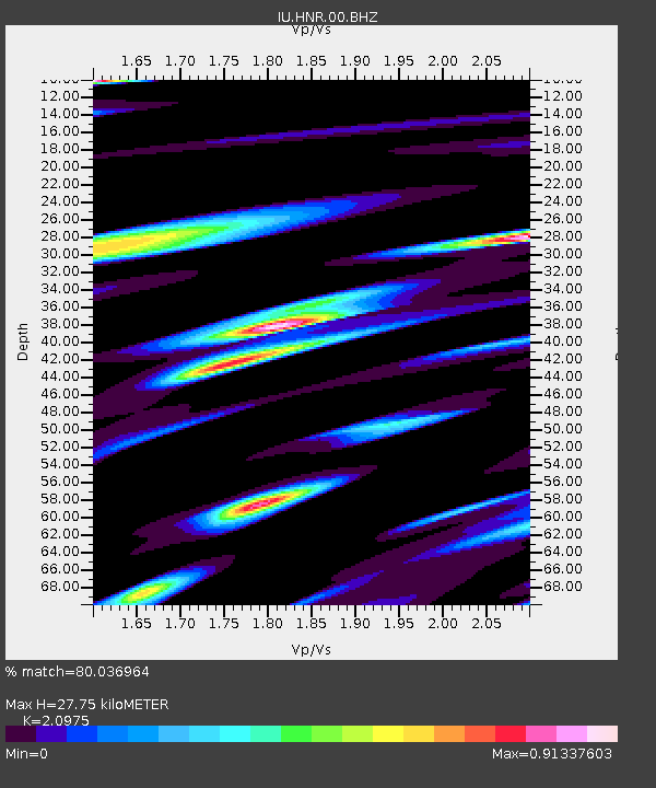
| Estimated Moho Depth: |
27.75 km |
| Estimated Crust Vp/Vs: |
2.10 |
| Assumed Crust Vp: |
6.183 km/s |
| Estimated Crust Vs: |
2.948 km/s |
| Estimated Crust Poisson's Ratio: |
0.35 |
|
| Radial Match: |
80.036964 % |
| Radial Bump: |
391 |
| Transverse Match: |
75.031136 % |
| Transverse Bump: |
400 |
| SOD ConfigId: |
558545 |
| Insert Time: |
2013-09-18 22:36:33.302 +0000 |
| GWidth: |
2.5 |
| Max Bumps: |
400 |
| Tol: |
0.001 |
|
Signal To Noise
| Channel | StoN | STA | LTA |
| IU:HNR:00:BHZ:20110716T17:12:12.619003Z | 7.8905835 | 4.8348356E-6 | 6.127349E-7 |
| IU:HNR:00:BH1:20110716T17:12:12.619003Z | 4.0174627 | 2.2845736E-6 | 5.686608E-7 |
| IU:HNR:00:BH2:20110716T17:12:12.619003Z | 4.684799 | 2.1071512E-6 | 4.4978478E-7 |
| Arrivals |
| Ps | 5.2 SECOND |
| PpPs | 13 SECOND |
| PsPs/PpSs | 18 SECOND |


