You are here: Home > Network List > YB13 - Continental Dynamics/Cent. Anatolian Tectonics:Surface to Mantle Dynamics During Stations List
> Station AT20 Kirkpinar,Kersehir,Turkey > Earthquake Result Viewer
AT20 Kirkpinar,Kersehir,Turkey - Earthquake Result Viewer
| Earthquake location: |
Iceland |
| Earthquake latitude/longitude: |
64.7/-17.4 |
| Earthquake time(UTC): |
2014/09/05 (248) 01:19:36 GMT |
| Earthquake Depth: |
2.0 km |
| Earthquake Magnitude: |
5.3 MW |
| Earthquake Catalog/Contributor: |
ISC/ISC |
|
| Network: |
YB Continental Dynamics/Cent. Anatolian Tectonics:Surface to Mantle Dynamics During |
| Station: |
AT20 Kirkpinar,Kersehir,Turkey |
| Lat/Lon: |
39.36 N/34.16 E |
| Elevation: |
1235 m |
|
| Distance: |
39.0 deg |
| Az: |
105.033 deg |
| Baz: |
327.614 deg |
| Ray Param: |
0.07526855 |
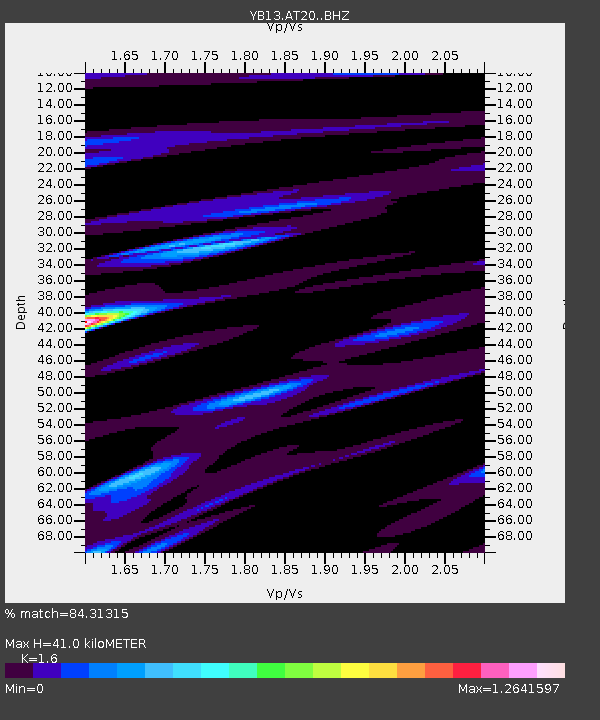
| Estimated Moho Depth: |
41.0 km |
| Estimated Crust Vp/Vs: |
1.60 |
| Assumed Crust Vp: |
6.35 km/s |
| Estimated Crust Vs: |
3.969 km/s |
| Estimated Crust Poisson's Ratio: |
0.18 |
|
| Radial Match: |
84.31315 % |
| Radial Bump: |
400 |
| Transverse Match: |
67.4524 % |
| Transverse Bump: |
400 |
| SOD ConfigId: |
3390531 |
| Insert Time: |
2019-04-13 20:55:12.082 +0000 |
| GWidth: |
2.5 |
| Max Bumps: |
400 |
| Tol: |
0.001 |
|

Signal To Noise
| Channel | StoN | STA | LTA |
| YB:AT20: :BHZ:20140905T01:26:33.598994Z | 4.8372393 | 2.0000604E-7 | 4.1347146E-8 |
| YB:AT20: :BHN:20140905T01:26:33.598994Z | 3.0080395 | 1.01718456E-7 | 3.381553E-8 |
| YB:AT20: :BHE:20140905T01:26:33.598994Z | 1.9505022 | 7.729058E-8 | 3.962599E-8 |
| Arrivals |
| Ps | 4.2 SECOND |
| PpPs | 16 SECOND |
| PsPs/PpSs | 20 SECOND |


