You are here: Home > Network List > CN - Canadian National Seismograph Network Stations List
> Station INK INUVIK, NT, CANADA.ANADA > Earthquake Result Viewer
INK INUVIK, NT, CANADA.ANADA - Earthquake Result Viewer
| Earthquake location: |
Vanuatu Islands |
| Earthquake latitude/longitude: |
-15.6/167.7 |
| Earthquake time(UTC): |
2007/08/01 (213) 17:08:51 GMT |
| Earthquake Depth: |
120 km |
| Earthquake Magnitude: |
6.2 MB, 7.2 MW, 7.2 MW |
| Earthquake Catalog/Contributor: |
WHDF/NEIC |
|
| Network: |
CN Canadian National Seismograph Network |
| Station: |
INK INUVIK, NT, CANADA.ANADA |
| Lat/Lon: |
68.31 N/133.52 W |
| Elevation: |
40 m |
|
| Distance: |
93.6 deg |
| Az: |
18.58 deg |
| Baz: |
235.678 deg |
| Ray Param: |
0.041164607 |
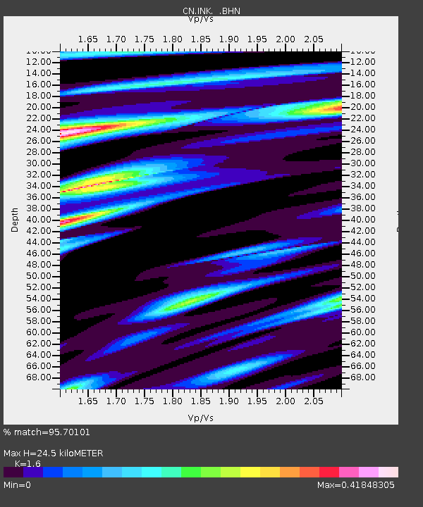
| Estimated Moho Depth: |
24.5 km |
| Estimated Crust Vp/Vs: |
1.60 |
| Assumed Crust Vp: |
6.171 km/s |
| Estimated Crust Vs: |
3.857 km/s |
| Estimated Crust Poisson's Ratio: |
0.18 |
|
| Radial Match: |
95.70101 % |
| Radial Bump: |
327 |
| Transverse Match: |
86.855606 % |
| Transverse Bump: |
400 |
| SOD ConfigId: |
2564 |
| Insert Time: |
2010-02-27 06:11:06.638 +0000 |
| GWidth: |
2.5 |
| Max Bumps: |
400 |
| Tol: |
0.001 |
|
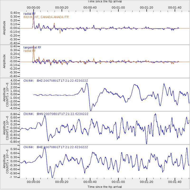
Signal To Noise
| Channel | StoN | STA | LTA |
| CN:INK: :BHN:20070801T17:21:22.623022Z | 4.186999 | 2.0305262E-7 | 4.849598E-8 |
| CN:INK: :BHE:20070801T17:21:22.623022Z | 6.4259377 | 2.7547813E-7 | 4.2869715E-8 |
| CN:INK: :BHZ:20070801T17:21:22.623022Z | 13.985701 | 1.0602813E-6 | 7.581181E-8 |
| Arrivals |
| Ps | 2.4 SECOND |
| PpPs | 10 SECOND |
| PsPs/PpSs | 13 SECOND |


