You are here: Home > Network List > CN - Canadian National Seismograph Network Stations List
> Station INK INUVIK, NT, CANADA.ANADA > Earthquake Result Viewer
INK INUVIK, NT, CANADA.ANADA - Earthquake Result Viewer
| Earthquake location: |
Northern Molucca Sea |
| Earthquake latitude/longitude: |
2.9/127.5 |
| Earthquake time(UTC): |
2007/07/26 (207) 05:40:16 GMT |
| Earthquake Depth: |
25 km |
| Earthquake Magnitude: |
6.4 MB, 6.8 MS, 6.9 MW, 6.9 MW |
| Earthquake Catalog/Contributor: |
WHDF/NEIC |
|
| Network: |
CN Canadian National Seismograph Network |
| Station: |
INK INUVIK, NT, CANADA.ANADA |
| Lat/Lon: |
68.31 N/133.52 W |
| Elevation: |
40 m |
|
| Distance: |
90.7 deg |
| Az: |
21.544 deg |
| Baz: |
279.428 deg |
| Ray Param: |
0.04165311 |
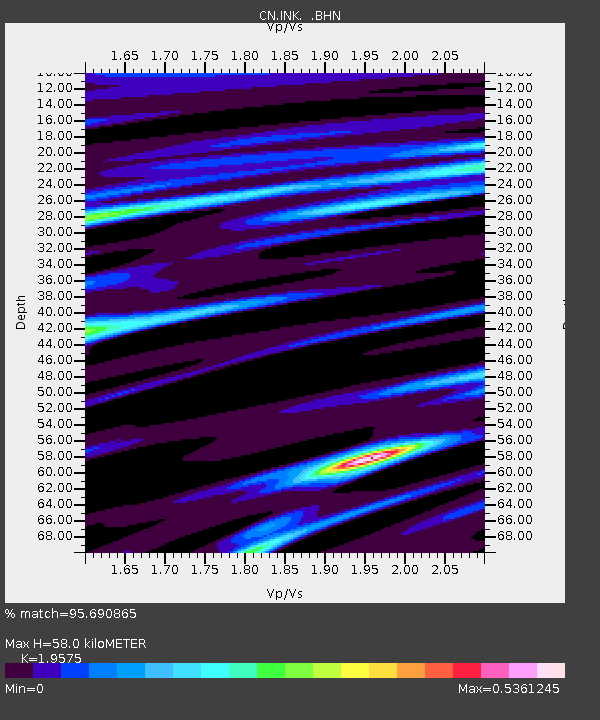
| Estimated Moho Depth: |
58.0 km |
| Estimated Crust Vp/Vs: |
1.96 |
| Assumed Crust Vp: |
6.171 km/s |
| Estimated Crust Vs: |
3.153 km/s |
| Estimated Crust Poisson's Ratio: |
0.32 |
|
| Radial Match: |
95.690865 % |
| Radial Bump: |
400 |
| Transverse Match: |
78.90326 % |
| Transverse Bump: |
400 |
| SOD ConfigId: |
2564 |
| Insert Time: |
2010-02-27 06:11:08.514 +0000 |
| GWidth: |
2.5 |
| Max Bumps: |
400 |
| Tol: |
0.001 |
|

Signal To Noise
| Channel | StoN | STA | LTA |
| CN:INK: :BHN:20070726T05:52:45.073022Z | 1.1341809 | 6.368339E-8 | 5.6149233E-8 |
| CN:INK: :BHE:20070726T05:52:45.073022Z | 8.9966545 | 4.8635786E-7 | 5.405986E-8 |
| CN:INK: :BHZ:20070726T05:52:45.073022Z | 16.53814 | 1.519768E-6 | 9.1894734E-8 |
| Arrivals |
| Ps | 9.2 SECOND |
| PpPs | 27 SECOND |
| PsPs/PpSs | 36 SECOND |


