You are here: Home > Network List > IU - Global Seismograph Network (GSN - IRIS/USGS) Stations List
> Station SJG San Juan, Puerto Rico > Earthquake Result Viewer
SJG San Juan, Puerto Rico - Earthquake Result Viewer
| Earthquake location: |
Alaska Peninsula |
| Earthquake latitude/longitude: |
54.8/-161.3 |
| Earthquake time(UTC): |
2011/07/16 (197) 19:59:12 GMT |
| Earthquake Depth: |
36 km |
| Earthquake Magnitude: |
6.3 MB, 5.9 MS, 6.2 MW, 6.1 MW |
| Earthquake Catalog/Contributor: |
WHDF/NEIC |
|
| Network: |
IU Global Seismograph Network (GSN - IRIS/USGS) |
| Station: |
SJG San Juan, Puerto Rico |
| Lat/Lon: |
18.11 N/66.15 W |
| Elevation: |
420 m |
|
| Distance: |
78.3 deg |
| Az: |
75.306 deg |
| Baz: |
323.908 deg |
| Ray Param: |
0.049671028 |
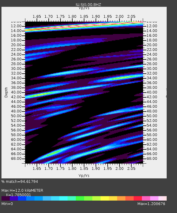
| Estimated Moho Depth: |
12.0 km |
| Estimated Crust Vp/Vs: |
1.79 |
| Assumed Crust Vp: |
5.14 km/s |
| Estimated Crust Vs: |
2.88 km/s |
| Estimated Crust Poisson's Ratio: |
0.27 |
|
| Radial Match: |
94.61794 % |
| Radial Bump: |
400 |
| Transverse Match: |
93.966736 % |
| Transverse Bump: |
400 |
| SOD ConfigId: |
558545 |
| Insert Time: |
2013-09-18 22:44:19.038 +0000 |
| GWidth: |
2.5 |
| Max Bumps: |
400 |
| Tol: |
0.001 |
|

Signal To Noise
| Channel | StoN | STA | LTA |
| IU:SJG:00:BHZ:20110716T20:10:38.319016Z | 18.681917 | 1.2449859E-6 | 6.6641235E-8 |
| IU:SJG:00:BH1:20110716T20:10:38.319016Z | 5.980717 | 4.0367246E-7 | 6.749566E-8 |
| IU:SJG:00:BH2:20110716T20:10:38.319016Z | 5.232586 | 3.5778743E-7 | 6.837679E-8 |
| Arrivals |
| Ps | 1.9 SECOND |
| PpPs | 6.4 SECOND |
| PsPs/PpSs | 8.2 SECOND |


