You are here: Home > Network List > IU - Global Seismograph Network (GSN - IRIS/USGS) Stations List
> Station SSPA Standing Stone, Pennsylvania > Earthquake Result Viewer
SSPA Standing Stone, Pennsylvania - Earthquake Result Viewer
| Earthquake location: |
Alaska Peninsula |
| Earthquake latitude/longitude: |
54.8/-161.3 |
| Earthquake time(UTC): |
2011/07/16 (197) 19:59:12 GMT |
| Earthquake Depth: |
36 km |
| Earthquake Magnitude: |
6.3 MB, 5.9 MS, 6.2 MW, 6.1 MW |
| Earthquake Catalog/Contributor: |
WHDF/NEIC |
|
| Network: |
IU Global Seismograph Network (GSN - IRIS/USGS) |
| Station: |
SSPA Standing Stone, Pennsylvania |
| Lat/Lon: |
40.64 N/77.89 W |
| Elevation: |
270 m |
|
| Distance: |
54.6 deg |
| Az: |
68.063 deg |
| Baz: |
315.091 deg |
| Ray Param: |
0.06528892 |
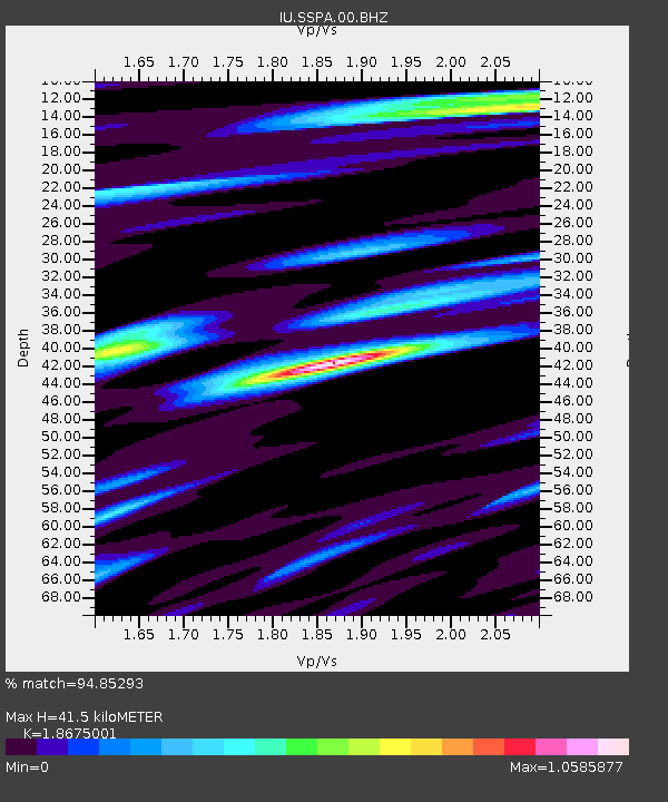
| Estimated Moho Depth: |
41.5 km |
| Estimated Crust Vp/Vs: |
1.87 |
| Assumed Crust Vp: |
6.121 km/s |
| Estimated Crust Vs: |
3.277 km/s |
| Estimated Crust Poisson's Ratio: |
0.30 |
|
| Radial Match: |
94.85293 % |
| Radial Bump: |
382 |
| Transverse Match: |
84.611275 % |
| Transverse Bump: |
400 |
| SOD ConfigId: |
558545 |
| Insert Time: |
2013-09-18 22:44:25.168 +0000 |
| GWidth: |
2.5 |
| Max Bumps: |
400 |
| Tol: |
0.001 |
|

Signal To Noise
| Channel | StoN | STA | LTA |
| IU:SSPA:00:BHZ:20110716T20:08:07.019028Z | 14.269515 | 1.4895521E-6 | 1.0438701E-7 |
| IU:SSPA:00:BH1:20110716T20:08:07.019028Z | 7.5567393 | 5.956895E-7 | 7.882891E-8 |
| IU:SSPA:00:BH2:20110716T20:08:07.019028Z | 5.6625924 | 4.836707E-7 | 8.541506E-8 |
| Arrivals |
| Ps | 6.2 SECOND |
| PpPs | 19 SECOND |
| PsPs/PpSs | 25 SECOND |


