You are here: Home > Network List > US - United States National Seismic Network Stations List
> Station CBN Corbin (Fredericksburg Observatory), Virginia, USA > Earthquake Result Viewer
CBN Corbin (Fredericksburg Observatory), Virginia, USA - Earthquake Result Viewer

| Earthquake location: |
Alaska Peninsula |
| Earthquake latitude/longitude: |
54.8/-161.3 |
| Earthquake time(UTC): |
2011/07/16 (197) 19:59:12 GMT |
| Earthquake Depth: |
36 km |
| Earthquake Magnitude: |
6.3 MB, 5.9 MS, 6.2 MW, 6.1 MW |
| Earthquake Catalog/Contributor: |
WHDF/NEIC |
|
| Network: |
US United States National Seismic Network |
| Station: |
CBN Corbin (Fredericksburg Observatory), Virginia, USA |
| Lat/Lon: |
38.21 N/77.37 W |
| Elevation: |
70 m |
|
| Distance: |
56.6 deg |
| Az: |
69.771 deg |
| Baz: |
316.382 deg |
| Ray Param: |
0.063966066 |
| Estimated Moho Depth: |
10.25 km |
| Estimated Crust Vp/Vs: |
2.07 |
| Assumed Crust Vp: |
6.419 km/s |
| Estimated Crust Vs: |
3.097 km/s |
| Estimated Crust Poisson's Ratio: |
0.35 |
|
| Radial Match: |
92.38682 % |
| Radial Bump: |
400 |
| Transverse Match: |
78.90688 % |
| Transverse Bump: |
400 |
| SOD ConfigId: |
558545 |
| Insert Time: |
2013-09-18 22:45:12.102 +0000 |
| GWidth: |
2.5 |
| Max Bumps: |
400 |
| Tol: |
0.001 |
|
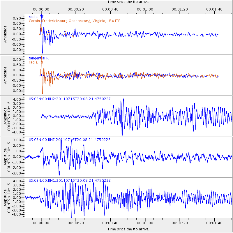
Signal To Noise
| Channel | StoN | STA | LTA |
| US:CBN:00:BHZ:20110716T20:08:21.475022Z | 8.605799 | 1.0705382E-6 | 1.243973E-7 |
| US:CBN:00:BH1:20110716T20:08:21.475022Z | 5.017619 | 1.3519252E-6 | 2.6943562E-7 |
| US:CBN:00:BH2:20110716T20:08:21.475022Z | 5.127445 | 9.3037715E-7 | 1.8145043E-7 |
| Arrivals |
| Ps | 1.8 SECOND |
| PpPs | 4.7 SECOND |
| PsPs/PpSs | 6.5 SECOND |


