You are here: Home > Network List > US - United States National Seismic Network Stations List
> Station EGMT Eagleton, Montana, USA > Earthquake Result Viewer
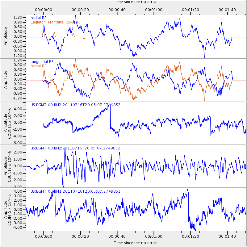
EGMT Eagleton, Montana, USA - Earthquake Result Viewer
*The percent match for this event was below the threshold and hence no stack was calculated.
| Earthquake location: |
Alaska Peninsula |
| Earthquake latitude/longitude: |
54.8/-161.3 |
| Earthquake time(UTC): |
2011/07/16 (197) 19:59:12 GMT |
| Earthquake Depth: |
36 km |
| Earthquake Magnitude: |
6.3 MB, 5.9 MS, 6.2 MW, 6.1 MW |
| Earthquake Catalog/Contributor: |
WHDF/NEIC |
|
| Network: |
US United States National Seismic Network |
| Station: |
EGMT Eagleton, Montana, USA |
| Lat/Lon: |
48.02 N/109.75 W |
| Elevation: |
1055 m |
|
| Distance: |
32.2 deg |
| Az: |
80.4 deg |
| Baz: |
301.709 deg |
| Ray Param: |
$rayparam |
*The percent match for this event was below the threshold and hence was not used in the summary stack. |
|
| Radial Match: |
62.7587 % |
| Radial Bump: |
400 |
| Transverse Match: |
49.486794 % |
| Transverse Bump: |
400 |
| SOD ConfigId: |
558545 |
| Insert Time: |
2013-09-18 22:45:29.852 +0000 |
| GWidth: |
2.5 |
| Max Bumps: |
400 |
| Tol: |
0.001 |
|
Signal To Noise
| Channel | StoN | STA | LTA |
| US:EGMT:00:BHZ:20110716T20:05:07.374985Z | 4.5296736 | 5.615977E-7 | 1.2398193E-7 |
| US:EGMT:00:BH1:20110716T20:05:07.374985Z | 2.395904 | 2.5149664E-6 | 1.0496941E-6 |
| US:EGMT:00:BH2:20110716T20:05:07.374985Z | 3.3228989 | 3.7731018E-6 | 1.135485E-6 |
| Arrivals |
| Ps | |
| PpPs | |
| PsPs/PpSs | |


