You are here: Home > Network List > US - United States National Seismic Network Stations List
> Station ERPA Erie, Pennsylvania, USA > Earthquake Result Viewer
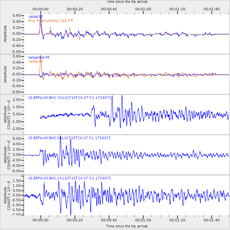
ERPA Erie, Pennsylvania, USA - Earthquake Result Viewer
| Earthquake location: |
Alaska Peninsula |
| Earthquake latitude/longitude: |
54.8/-161.3 |
| Earthquake time(UTC): |
2011/07/16 (197) 19:59:12 GMT |
| Earthquake Depth: |
36 km |
| Earthquake Magnitude: |
6.3 MB, 5.9 MS, 6.2 MW, 6.1 MW |
| Earthquake Catalog/Contributor: |
WHDF/NEIC |
|
| Network: |
US United States National Seismic Network |
| Station: |
ERPA Erie, Pennsylvania, USA |
| Lat/Lon: |
42.12 N/79.99 W |
| Elevation: |
306 m |
|
| Distance: |
52.4 deg |
| Az: |
68.125 deg |
| Baz: |
313.744 deg |
| Ray Param: |
0.06670064 |
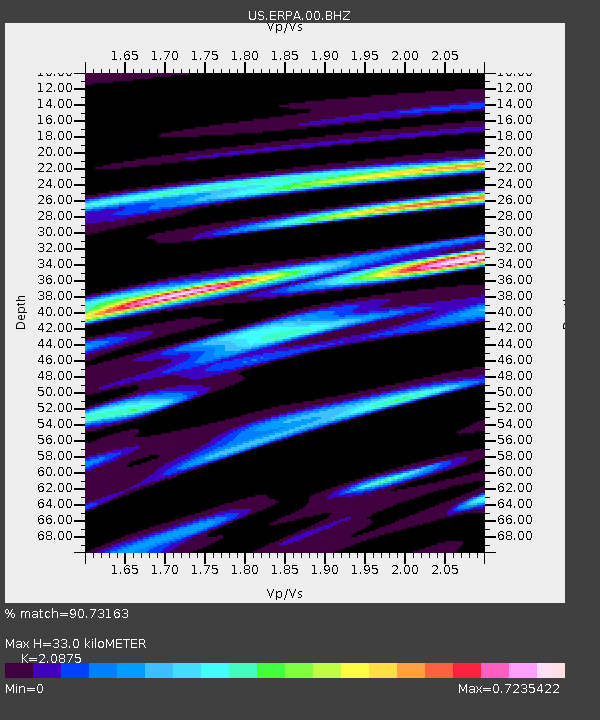
| Estimated Moho Depth: |
33.0 km |
| Estimated Crust Vp/Vs: |
2.09 |
| Assumed Crust Vp: |
6.419 km/s |
| Estimated Crust Vs: |
3.075 km/s |
| Estimated Crust Poisson's Ratio: |
0.35 |
|
| Radial Match: |
90.73163 % |
| Radial Bump: |
400 |
| Transverse Match: |
78.16682 % |
| Transverse Bump: |
400 |
| SOD ConfigId: |
558545 |
| Insert Time: |
2013-09-18 22:45:35.115 +0000 |
| GWidth: |
2.5 |
| Max Bumps: |
400 |
| Tol: |
0.001 |
|
Signal To Noise
| Channel | StoN | STA | LTA |
| US:ERPA:00:BHZ:20110716T20:07:51.173997Z | 13.799801 | 1.6340458E-6 | 1.1841082E-7 |
| US:ERPA:00:BH1:20110716T20:07:51.173997Z | 5.607552 | 5.198232E-7 | 9.270056E-8 |
| US:ERPA:00:BH2:20110716T20:07:51.173997Z | 4.275056 | 6.7742224E-7 | 1.5845927E-7 |
| Arrivals |
| Ps | 5.9 SECOND |
| PpPs | 15 SECOND |
| PsPs/PpSs | 21 SECOND |


