You are here: Home > Network List > US - United States National Seismic Network Stations List
> Station MIAR Mount Ida, Arkansas, USA > Earthquake Result Viewer
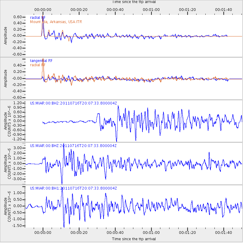
MIAR Mount Ida, Arkansas, USA - Earthquake Result Viewer
| Earthquake location: |
Alaska Peninsula |
| Earthquake latitude/longitude: |
54.8/-161.3 |
| Earthquake time(UTC): |
2011/07/16 (197) 19:59:12 GMT |
| Earthquake Depth: |
36 km |
| Earthquake Magnitude: |
6.3 MB, 5.9 MS, 6.2 MW, 6.1 MW |
| Earthquake Catalog/Contributor: |
WHDF/NEIC |
|
| Network: |
US United States National Seismic Network |
| Station: |
MIAR Mount Ida, Arkansas, USA |
| Lat/Lon: |
34.55 N/93.58 W |
| Elevation: |
207 m |
|
| Distance: |
50.1 deg |
| Az: |
84.633 deg |
| Baz: |
315.685 deg |
| Ray Param: |
0.068208486 |
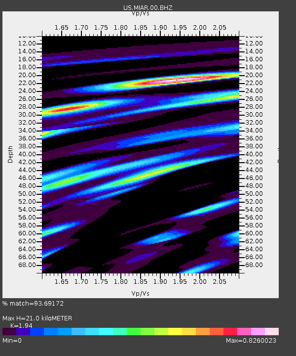
| Estimated Moho Depth: |
21.0 km |
| Estimated Crust Vp/Vs: |
1.94 |
| Assumed Crust Vp: |
6.498 km/s |
| Estimated Crust Vs: |
3.349 km/s |
| Estimated Crust Poisson's Ratio: |
0.32 |
|
| Radial Match: |
93.69172 % |
| Radial Bump: |
400 |
| Transverse Match: |
52.110565 % |
| Transverse Bump: |
400 |
| SOD ConfigId: |
558545 |
| Insert Time: |
2013-09-18 22:46:14.219 +0000 |
| GWidth: |
2.5 |
| Max Bumps: |
400 |
| Tol: |
0.001 |
|
Signal To Noise
| Channel | StoN | STA | LTA |
| US:MIAR:00:BHZ:20110716T20:07:33.800004Z | 15.264112 | 8.452849E-7 | 5.537727E-8 |
| US:MIAR:00:BH1:20110716T20:07:33.800004Z | 2.834668 | 3.4672843E-7 | 1.2231713E-7 |
| US:MIAR:00:BH2:20110716T20:07:33.800004Z | 8.129166 | 3.5341398E-7 | 4.3474817E-8 |
| Arrivals |
| Ps | 3.2 SECOND |
| PpPs | 9.0 SECOND |
| PsPs/PpSs | 12 SECOND |


