You are here: Home > Network List > US - United States National Seismic Network Stations List
> Station MNTX Cornudas Mountains, Texas, USA > Earthquake Result Viewer
MNTX Cornudas Mountains, Texas, USA - Earthquake Result Viewer
| Earthquake location: |
Alaska Peninsula |
| Earthquake latitude/longitude: |
54.8/-161.3 |
| Earthquake time(UTC): |
2011/07/16 (197) 19:59:12 GMT |
| Earthquake Depth: |
36 km |
| Earthquake Magnitude: |
6.3 MB, 5.9 MS, 6.2 MW, 6.1 MW |
| Earthquake Catalog/Contributor: |
WHDF/NEIC |
|
| Network: |
US United States National Seismic Network |
| Station: |
MNTX Cornudas Mountains, Texas, USA |
| Lat/Lon: |
31.70 N/105.38 W |
| Elevation: |
404 m |
|
| Distance: |
45.3 deg |
| Az: |
96.996 deg |
| Baz: |
317.589 deg |
| Ray Param: |
0.071269564 |
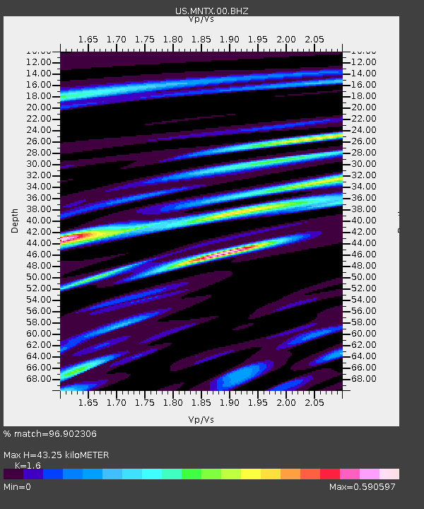
| Estimated Moho Depth: |
43.25 km |
| Estimated Crust Vp/Vs: |
1.60 |
| Assumed Crust Vp: |
6.361 km/s |
| Estimated Crust Vs: |
3.975 km/s |
| Estimated Crust Poisson's Ratio: |
0.18 |
|
| Radial Match: |
96.902306 % |
| Radial Bump: |
341 |
| Transverse Match: |
85.13898 % |
| Transverse Bump: |
400 |
| SOD ConfigId: |
558545 |
| Insert Time: |
2013-09-18 22:46:19.085 +0000 |
| GWidth: |
2.5 |
| Max Bumps: |
400 |
| Tol: |
0.001 |
|
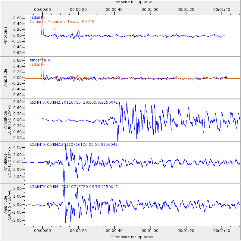
Signal To Noise
| Channel | StoN | STA | LTA |
| US:MNTX:00:BHZ:20110716T20:06:56.925004Z | 6.0499277 | 3.6584834E-7 | 6.047152E-8 |
| US:MNTX:00:BH1:20110716T20:06:56.925004Z | 2.8710945 | 1.4743836E-7 | 5.1352668E-8 |
| US:MNTX:00:BH2:20110716T20:06:56.925004Z | 2.2815785 | 8.887543E-8 | 3.8953484E-8 |
| Arrivals |
| Ps | 4.4 SECOND |
| PpPs | 16 SECOND |
| PsPs/PpSs | 21 SECOND |


