You are here: Home > Network List > GS - US Geological Survey Networks Stations List
> Station KAN13 Rinehart Farm > Earthquake Result Viewer
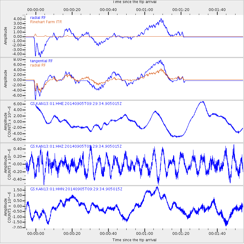
KAN13 Rinehart Farm - Earthquake Result Viewer
*The percent match for this event was below the threshold and hence no stack was calculated.
| Earthquake location: |
Easter Island Region |
| Earthquake latitude/longitude: |
-26.7/-114.5 |
| Earthquake time(UTC): |
2014/09/05 (248) 09:19:23 GMT |
| Earthquake Depth: |
10 km |
| Earthquake Magnitude: |
4.9 MW |
| Earthquake Catalog/Contributor: |
ISC/ISC |
|
| Network: |
GS US Geological Survey Networks |
| Station: |
KAN13 Rinehart Farm |
| Lat/Lon: |
37.01 N/97.48 W |
| Elevation: |
340 m |
|
| Distance: |
65.3 deg |
| Az: |
14.906 deg |
| Baz: |
196.712 deg |
| Ray Param: |
$rayparam |
*The percent match for this event was below the threshold and hence was not used in the summary stack. |
|
| Radial Match: |
35.44229 % |
| Radial Bump: |
400 |
| Transverse Match: |
36.732105 % |
| Transverse Bump: |
400 |
| SOD ConfigId: |
3390531 |
| Insert Time: |
2019-04-13 20:59:13.359 +0000 |
| GWidth: |
2.5 |
| Max Bumps: |
400 |
| Tol: |
0.001 |
|
Signal To Noise
| Channel | StoN | STA | LTA |
| GS:KAN13:01:HHZ:20140905T09:29:34.905015Z | 1.5179701 | 2.3462475E-7 | 1.545648E-7 |
| GS:KAN13:01:HHN:20140905T09:29:34.905015Z | 1.8445246 | 1.0239995E-6 | 5.551563E-7 |
| GS:KAN13:01:HHE:20140905T09:29:34.905015Z | 1.362632 | 2.663039E-6 | 1.9543345E-6 |
| Arrivals |
| Ps | |
| PpPs | |
| PsPs/PpSs | |


