You are here: Home > Network List > US - United States National Seismic Network Stations List
> Station EGMT Eagleton, Montana, USA > Earthquake Result Viewer
EGMT Eagleton, Montana, USA - Earthquake Result Viewer
*The percent match for this event was below the threshold and hence no stack was calculated.
| Earthquake location: |
Northwest Of Kuril Islands |
| Earthquake latitude/longitude: |
52.8/152.9 |
| Earthquake time(UTC): |
2011/07/18 (199) 18:15:24 GMT |
| Earthquake Depth: |
494 km |
| Earthquake Magnitude: |
5.5 MW |
| Earthquake Catalog/Contributor: |
NEIC PDE/NEIC PDE-M |
|
| Network: |
US United States National Seismic Network |
| Station: |
EGMT Eagleton, Montana, USA |
| Lat/Lon: |
48.02 N/109.75 W |
| Elevation: |
1055 m |
|
| Distance: |
57.5 deg |
| Az: |
52.129 deg |
| Baz: |
314.441 deg |
| Ray Param: |
$rayparam |
*The percent match for this event was below the threshold and hence was not used in the summary stack. |
|
| Radial Match: |
55.6942 % |
| Radial Bump: |
400 |
| Transverse Match: |
60.282253 % |
| Transverse Bump: |
400 |
| SOD ConfigId: |
558545 |
| Insert Time: |
2013-09-18 22:49:20.977 +0000 |
| GWidth: |
2.5 |
| Max Bumps: |
400 |
| Tol: |
0.001 |
|
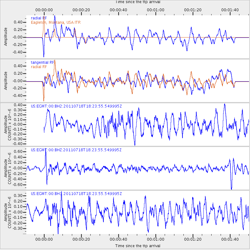
Signal To Noise
| Channel | StoN | STA | LTA |
| US:EGMT:00:BHZ:20110718T18:23:55.549995Z | 3.010315 | 2.3766691E-7 | 7.895084E-8 |
| US:EGMT:00:BH1:20110718T18:23:55.549995Z | 1.0647608 | 1.2572161E-7 | 1.1807498E-7 |
| US:EGMT:00:BH2:20110718T18:23:55.549995Z | 1.3177854 | 1.4958572E-7 | 1.1351296E-7 |
| Arrivals |
| Ps | |
| PpPs | |
| PsPs/PpSs | |


