You are here: Home > Network List > US - United States National Seismic Network Stations List
> Station MSO Missoula, Montana, USA > Earthquake Result Viewer
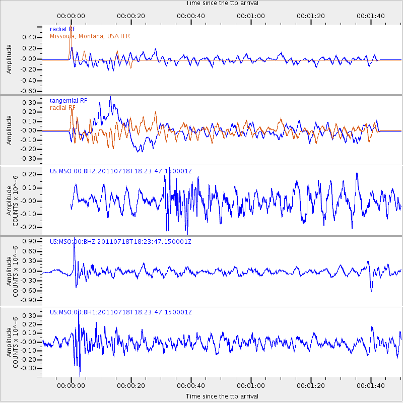
MSO Missoula, Montana, USA - Earthquake Result Viewer
*The percent match for this event was below the threshold and hence no stack was calculated.
| Earthquake location: |
Northwest Of Kuril Islands |
| Earthquake latitude/longitude: |
52.8/152.9 |
| Earthquake time(UTC): |
2011/07/18 (199) 18:15:24 GMT |
| Earthquake Depth: |
494 km |
| Earthquake Magnitude: |
5.5 MW |
| Earthquake Catalog/Contributor: |
NEIC PDE/NEIC PDE-M |
|
| Network: |
US United States National Seismic Network |
| Station: |
MSO Missoula, Montana, USA |
| Lat/Lon: |
46.83 N/113.94 W |
| Elevation: |
1264 m |
|
| Distance: |
56.3 deg |
| Az: |
55.508 deg |
| Baz: |
313.212 deg |
| Ray Param: |
$rayparam |
*The percent match for this event was below the threshold and hence was not used in the summary stack. |
|
| Radial Match: |
54.275806 % |
| Radial Bump: |
400 |
| Transverse Match: |
46.03914 % |
| Transverse Bump: |
400 |
| SOD ConfigId: |
558545 |
| Insert Time: |
2013-09-18 22:49:50.206 +0000 |
| GWidth: |
2.5 |
| Max Bumps: |
400 |
| Tol: |
0.001 |
|
Signal To Noise
| Channel | StoN | STA | LTA |
| US:MSO:00:BHZ:20110718T18:23:47.150001Z | 5.943483 | 2.7631148E-7 | 4.6489827E-8 |
| US:MSO:00:BH1:20110718T18:23:47.150001Z | 2.3515484 | 1.541463E-7 | 6.5550985E-8 |
| US:MSO:00:BH2:20110718T18:23:47.150001Z | 1.6625369 | 9.680712E-8 | 5.8228558E-8 |
| Arrivals |
| Ps | |
| PpPs | |
| PsPs/PpSs | |


