You are here: Home > Network List > TA - USArray Transportable Network (new EarthScope stations) Stations List
> Station E47A Iron Bridge, ON, CAN > Earthquake Result Viewer
E47A Iron Bridge, ON, CAN - Earthquake Result Viewer
| Earthquake location: |
Easter Island Region |
| Earthquake latitude/longitude: |
-26.7/-114.5 |
| Earthquake time(UTC): |
2014/09/05 (248) 09:19:23 GMT |
| Earthquake Depth: |
10 km |
| Earthquake Magnitude: |
4.9 MW |
| Earthquake Catalog/Contributor: |
ISC/ISC |
|
| Network: |
TA USArray Transportable Network (new EarthScope stations) |
| Station: |
E47A Iron Bridge, ON, CAN |
| Lat/Lon: |
46.45 N/83.28 W |
| Elevation: |
246 m |
|
| Distance: |
78.1 deg |
| Az: |
21.459 deg |
| Baz: |
208.262 deg |
| Ray Param: |
0.049893018 |
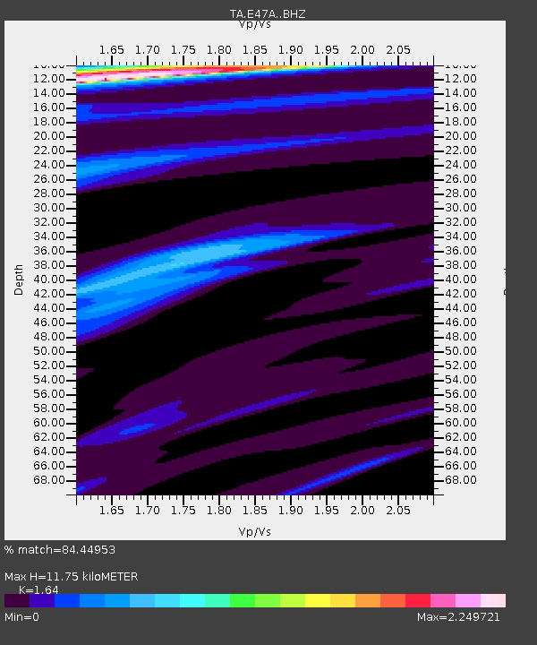
| Estimated Moho Depth: |
11.75 km |
| Estimated Crust Vp/Vs: |
1.64 |
| Assumed Crust Vp: |
6.467 km/s |
| Estimated Crust Vs: |
3.943 km/s |
| Estimated Crust Poisson's Ratio: |
0.20 |
|
| Radial Match: |
84.44953 % |
| Radial Bump: |
400 |
| Transverse Match: |
37.840412 % |
| Transverse Bump: |
388 |
| SOD ConfigId: |
3390531 |
| Insert Time: |
2019-04-13 21:01:46.931 +0000 |
| GWidth: |
2.5 |
| Max Bumps: |
400 |
| Tol: |
0.001 |
|

Signal To Noise
| Channel | StoN | STA | LTA |
| TA:E47A: :BHZ:20140905T09:30:51.374985Z | 1.0979143 | 2.613971E-7 | 2.3808516E-7 |
| TA:E47A: :BHN:20140905T09:30:51.374985Z | 2.6427207 | 5.371116E-7 | 2.0324191E-7 |
| TA:E47A: :BHE:20140905T09:30:51.374985Z | 1.3183061 | 3.3182684E-7 | 2.5170698E-7 |
| Arrivals |
| Ps | 1.2 SECOND |
| PpPs | 4.6 SECOND |
| PsPs/PpSs | 5.8 SECOND |


