You are here: Home > Network List > US - United States National Seismic Network Stations List
> Station HAWA Hanford, Washington, USA > Earthquake Result Viewer
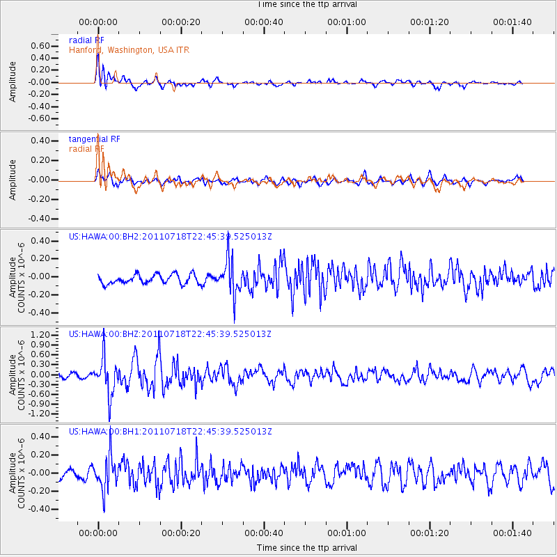
HAWA Hanford, Washington, USA - Earthquake Result Viewer
*The percent match for this event was below the threshold and hence no stack was calculated.
| Earthquake location: |
Rat Islands, Aleutian Islands |
| Earthquake latitude/longitude: |
51.3/178.9 |
| Earthquake time(UTC): |
2011/07/18 (199) 22:38:38 GMT |
| Earthquake Depth: |
19 km |
| Earthquake Magnitude: |
5.8 MW, 5.3 MS, 5.4 MB, 5.8 MW |
| Earthquake Catalog/Contributor: |
WHDF/NEIC |
|
| Network: |
US United States National Seismic Network |
| Station: |
HAWA Hanford, Washington, USA |
| Lat/Lon: |
46.39 N/119.53 W |
| Elevation: |
364 m |
|
| Distance: |
39.7 deg |
| Az: |
72.099 deg |
| Baz: |
300.288 deg |
| Ray Param: |
$rayparam |
*The percent match for this event was below the threshold and hence was not used in the summary stack. |
|
| Radial Match: |
77.190674 % |
| Radial Bump: |
400 |
| Transverse Match: |
70.96447 % |
| Transverse Bump: |
400 |
| SOD ConfigId: |
558545 |
| Insert Time: |
2013-09-18 22:53:00.865 +0000 |
| GWidth: |
2.5 |
| Max Bumps: |
400 |
| Tol: |
0.001 |
|
Signal To Noise
| Channel | StoN | STA | LTA |
| US:HAWA:00:BHZ:20110718T22:45:39.525013Z | 7.67744 | 5.6382385E-7 | 7.343905E-8 |
| US:HAWA:00:BH1:20110718T22:45:39.525013Z | 2.7985413 | 1.8780551E-7 | 6.710836E-8 |
| US:HAWA:00:BH2:20110718T22:45:39.525013Z | 3.9526064 | 2.0343995E-7 | 5.1469826E-8 |
| Arrivals |
| Ps | |
| PpPs | |
| PsPs/PpSs | |


