You are here: Home > Network List > TA - USArray Transportable Network (new EarthScope stations) Stations List
> Station H61A Lyndonville, VT, USA > Earthquake Result Viewer
H61A Lyndonville, VT, USA - Earthquake Result Viewer
| Earthquake location: |
Easter Island Region |
| Earthquake latitude/longitude: |
-26.7/-114.5 |
| Earthquake time(UTC): |
2014/09/05 (248) 09:19:23 GMT |
| Earthquake Depth: |
10 km |
| Earthquake Magnitude: |
4.9 MW |
| Earthquake Catalog/Contributor: |
ISC/ISC |
|
| Network: |
TA USArray Transportable Network (new EarthScope stations) |
| Station: |
H61A Lyndonville, VT, USA |
| Lat/Lon: |
44.53 N/71.93 W |
| Elevation: |
462 m |
|
| Distance: |
80.8 deg |
| Az: |
29.323 deg |
| Baz: |
217.788 deg |
| Ray Param: |
0.048019815 |
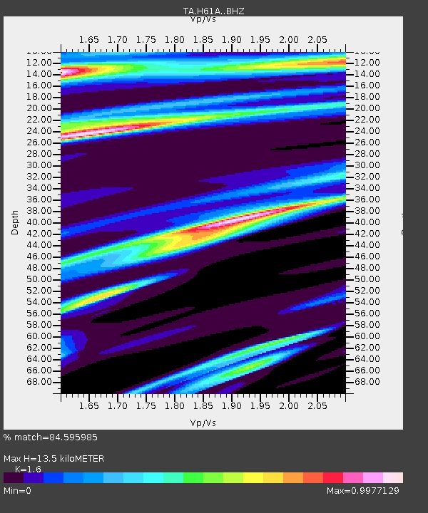
| Estimated Moho Depth: |
13.5 km |
| Estimated Crust Vp/Vs: |
1.60 |
| Assumed Crust Vp: |
6.419 km/s |
| Estimated Crust Vs: |
4.012 km/s |
| Estimated Crust Poisson's Ratio: |
0.18 |
|
| Radial Match: |
84.595985 % |
| Radial Bump: |
393 |
| Transverse Match: |
69.05559 % |
| Transverse Bump: |
372 |
| SOD ConfigId: |
3390531 |
| Insert Time: |
2019-04-13 21:01:56.364 +0000 |
| GWidth: |
2.5 |
| Max Bumps: |
400 |
| Tol: |
0.001 |
|

Signal To Noise
| Channel | StoN | STA | LTA |
| TA:H61A: :BHZ:20140905T09:31:06.249985Z | 1.8236158 | 5.433404E-7 | 2.9794674E-7 |
| TA:H61A: :BHN:20140905T09:31:06.249985Z | 1.2009662 | 2.2752438E-7 | 1.8945109E-7 |
| TA:H61A: :BHE:20140905T09:31:06.249985Z | 1.3691767 | 3.510859E-7 | 2.5642117E-7 |
| Arrivals |
| Ps | 1.3 SECOND |
| PpPs | 5.3 SECOND |
| PsPs/PpSs | 6.6 SECOND |


