You are here: Home > Network List > TA - USArray Transportable Network (new EarthScope stations) Stations List
> Station I61A Oroboro, Fairlee, VT, USA > Earthquake Result Viewer
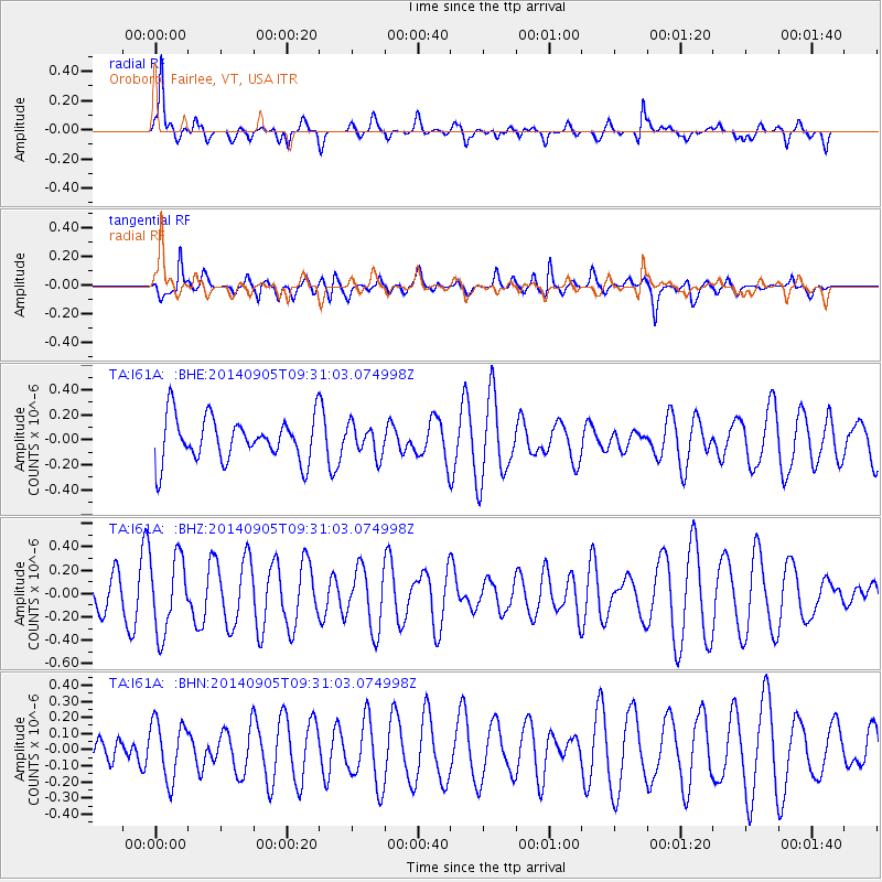
I61A Oroboro, Fairlee, VT, USA - Earthquake Result Viewer
*The percent match for this event was below the threshold and hence no stack was calculated.
| Earthquake location: |
Easter Island Region |
| Earthquake latitude/longitude: |
-26.7/-114.5 |
| Earthquake time(UTC): |
2014/09/05 (248) 09:19:23 GMT |
| Earthquake Depth: |
10 km |
| Earthquake Magnitude: |
4.9 MW |
| Earthquake Catalog/Contributor: |
ISC/ISC |
|
| Network: |
TA USArray Transportable Network (new EarthScope stations) |
| Station: |
I61A Oroboro, Fairlee, VT, USA |
| Lat/Lon: |
43.93 N/72.21 W |
| Elevation: |
287 m |
|
| Distance: |
80.2 deg |
| Az: |
29.533 deg |
| Baz: |
217.627 deg |
| Ray Param: |
$rayparam |
*The percent match for this event was below the threshold and hence was not used in the summary stack. |
|
| Radial Match: |
70.811424 % |
| Radial Bump: |
400 |
| Transverse Match: |
43.80072 % |
| Transverse Bump: |
400 |
| SOD ConfigId: |
3390531 |
| Insert Time: |
2019-04-13 21:01:59.567 +0000 |
| GWidth: |
2.5 |
| Max Bumps: |
400 |
| Tol: |
0.001 |
|
Signal To Noise
| Channel | StoN | STA | LTA |
| TA:I61A: :BHZ:20140905T09:31:03.074998Z | 2.4292393 | 3.253784E-7 | 1.339425E-7 |
| TA:I61A: :BHN:20140905T09:31:03.074998Z | 1.8849667 | 1.794531E-7 | 9.520226E-8 |
| TA:I61A: :BHE:20140905T09:31:03.074998Z | 0.69236946 | 1.2128204E-7 | 1.7516955E-7 |
| Arrivals |
| Ps | |
| PpPs | |
| PsPs/PpSs | |


